Inside
Down Undertc "Inside Down Under"
by Dennis Lewon
Below the rim in Australia, where it’s no exaggeration to say that
the canyons may just hold the key to life.
They say that obsession is halfway between love and madness. If so, Richard
D. Fisher is precariously balanced on the razor’s edge of performance
in nature and artistic interpretation of canyons on a global basis. The
American explorer and canyoneer has spent the better part of a lifetime
immersed in the world’s canyon country. He’s launched expeditions
to some of earth’s most remote gorges, from Arizona to Bolivia to
Tibet, where he was the first American to document the earth’s deepest
canyon. For over three decades he has steeped himself in canyons and canyon
cultures worldwide. So it should come as no surprise that when Fisher
got wind of several intense and little known canyon systems in Australia,
he became obsessed.
Fisher’s Australia obsession began with a gift. In 1996 the Explorers
Club presented him with a copy of ORBIT: NASA Astronauts Photograph the
Earth. As Fisher flipped through the colorful photos taken from outer
space, he came to an impressive double-page spread devoted to Australia
that stopped him cold. It was a picture of a sprawling impact crater from
an ancient meteorite. A complex canyon system surrounded the crater site,
and the mysteries of the crumpled geography immediately captured Fisher’s
attention. This, he thought, I have to see for myself.
So began Fisher’s odyssey Down Under. From 1997-2000 he made three extensive forays to Australia, following the trail of the mysterious NASA photograph and finding world-class canyons on both east and west coasts. With help from numerous Australian canyoneers, scientists, park rangers and helicopter pilots, Fisher was able to make the first known comprehensive inventory and documentation of the canyons of Australia. “They’re very much like the canyons I grew up with,” says Fisher, who cut his canyoneering teeth in the Southwestern United States. “Australia is an amazingly safe place, like America in the 1950s and 60s, so it is very pleasant to travel there. The continent is so big and some places are so isolated. There are many fantastic locations just now becoming known to the rest of the world.”
Remarkable canyon country isn’t all Fisher found. While hunting for the NASA photo, he found himself on the trail of another mystery---the search for the origins of life on earth. While investigating the geology of the area, he uncovered recent, original research by Australian scientists that seemed systematically related, like separate pieces of a jigsaw puzzle. Fisher became the first person known to this point to put the pieces together.
The first piece was provided by Australian National University geologist Dr. Andrew Glikson, who helped Fisher in his search for the site of the NASA photo. Dr. Glikson had previously done work on other meteorite craters and their relationship to earth’s earliest microorganisms. “These bacteria love volcanic environments and they love post impact environments,” says Glikson.
The second thread of research came from a joint effort by University of Sydney School of Geosciences and the Australian Geological Survey Organization headed by Roger Buick Ph.D. The study in northwestern Australia’s Karijini region found evidence of life some 2.75 billion-years old—nearly one billion-years older than anything previously recorded. The final piece of the puzzle came from a CSIRO Exploration and Mining expedition to hunt for “extremophile microbes” These microorganisms process minerals in total darkness in boiling hot undersea vents. The vents are formed in the Pacific Ocean north of Australia. The CSIRO team was dredging the sea floor a mile beneath the surface of the ocean when the ship snagged and recovered a black smoker, or chimney, that was teeming with bacteria. Microbiologist Dr. Peter Franzmann believes the bizarre bugs may be related to some of the earliest forms of life on earth. The microbes’ existence in these extreme environments make it feasible that conditions such as those on early earth, or even on Mars and other planets, may also be capable of supporting basic life-forms.
After putting these three discoveries together, Fisher says, “I now believe the canyons and impact craters of central and western Australia hold the keys to deciphering the origins of life on earth.”
The exact location of the NASA photo’s crater site and its associated canyons proved to be nearly as elusive as the origins of life itself. The photo Fisher had started with turned out to be mislabeled, upside down and inverted on the page. The only clue he had was a picture of striking sandstone domes next to the NASA photo that appeared to show a close-up of the crater’s other worldly terrain.
This explains, in a roundabout way, how Fisher eventually found himself boarding a helicopter for Purnululu National Park in northern Australia. He had tracked the distinctive beehive-shaped domes to the park’s Bungle Bungle Range, far from the area indicated by the photo caption. “It was a serendipitous mistake,” explains Fisher. “The book editors accidentally put the picture of the Bungle Bungles on the same page as the crater photo. Otherwise, I probably never would have come here. That would have been the real mistake. The Bungle Bungles are mind-boggling, like a place from another planet.” This mistake, as is often the case in exploration, led to a unique turn of events and surprising discoveries.
Purnululu is located at the end of a rough four-wheel-drive track about 100 miles south of Kununurra in the Northern Territory. Because of sheer isolation, the park’s surreal sandstone domes—striped with horizontal bands of orange and gray—have only recently entered the radar screen of mainstream Australia. Until the mid-1980s the bizarre Bungle Bungle domes were known only to the Aboriginal people and a handful of Australians working the outback. The long dirt track approach to the isolated range is only passable during the dry season. Last year’s extraordinarily wet season kept the region closed until very late, so a helicopter was Fisher’s only option to complete the survey. Initially a big blow to the budget, the helicopter later turned out to be the key to new discoveries and insights.
The 360 million year old sandstone of the Bungle Bungles gets its unique stripes from alternating layers of rock that have a different clay content and porosity. Cyanobacteria (blue-green algae) grows where the layering allows moisture to accumulate, creating the dark gray color. The orange bands are the result of oxidized iron compounds in layers that are too dry for the bacteria. Erosion is responsible for the shape of the unique domes and a network of associated canyons.
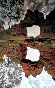
With the help of local helicopter pilots and park rangers, Fisher was able to make an extensive survey of Purnululu and its geographical features. Most visitors to the Bungle Bungle Range walk up the Piccanniny Gorge, which snakes through naked rock and along a creek before ending abruptly at an impassable waterfall ten miles from the mouth of the gorge. With the use of a helicopter, Fisher was able to explore beyond the falls. From the air he spied an unrecorded stone arch measuring some seventy feet high and thirty feet across. Later, investigations on foot revealed the arch is a natural bridge across a small creek—an extremely rare geologic feature, considering the fragile nature of
the rock.
Fisher also photographed the Piccanniny Circular Structure, a meteorite impact crater similar to but smaller than the one in the NASA photo. This elliptical-shaped crater is some five miles across. It’s obvious that when the asteroid slammed into the earth it changed the physical terrain. But some people, including the local Kija Aborigines, believe it changed the spiritual landscape as well. Fisher concurs with this observation. On his last trip to the Bungle Bungles, Fisher spent time alone in the remote northwest part of the park where he found unusual arches of conglomerate rock. “You can’t see what’s holding them together,” he recalls. “I don’t know how to describe it. It is like a place not from this earth.”
Fisher’s quest to find the NASA photo had been transformed into an obsession after three years of searching. He wanted to learn all he could about the canyons of Australia. To that end he traveled to the Blue Mountains near Sydney, where the soft sandstone is riddled with hundreds of deep, narrow, serpentine canyons, many of which require technical canyoneering to negotiate. There Fisher met up with Rick Jamieson, considered one of the pioneers of modern Australian canyon exploration. Fisher had the pleasure of photographing numerous gorges and slot canyons with one of the friendliest and most skilled canyoneers on earth.
After solving the language barrier (Australians call anything bigger than a slot canyon a gorge), Fisher discovered there are a number of similarities between American and Australian canyoneers. Unknown to each other, but at about the same time in the 1960s and 70s, explorers in both countries were developing the technical skills and equipment needed to penetrate the deepest, narrowest canyons sliced into stone. They perfected the art of rappelling, climbing, trekking, swimming and rafting all on one trip while carrying all of the equipment on their backs. As a leader in the evolution of canyoneering and the author of a guidebook on the Blue Mountains, Jamieson proved to be just the person to introduce Fisher to the area’s canyons.
In the Blue Mountains Fisher found a dramatically different environment from the canyon country in central, western and northern Australia. With Jamieson and other local canyoneers, Fisher rappelled into steep-walled slots whose sides are covered with moss, ferns and other lush growth. They swam and floated dim, cool, creek bottoms where direct sunlight never reaches. They walked through dark grottoes where glow worms light up the night. They rappelled through a waterfall in Claustral Canyon. They took pictures. Afterward Fisher noted, “If you can photograph in the Blue Mountains, you can photograph anywhere.” This was by far the most difficult canyon photographic challenge he has ever encountered. Rain, darkness, and very cold water make top quality professional photography almost impossible.
Since only about half the Blue Mountains’ maze of some four hundred canyons has been documented, Fisher contented himself with sampling a handful that his hosts recommended, introducing his new friends to the subtler joys of canyoneering. “They had never thought of staying in one place for a whole day,” says Fisher. “Having a relaxing lunch, exploring a single stretch of water and all its hidden details, just enjoying the canyon in a different way was a new idea to them.” In Australia it is the technical challenges that motivate the Blue Mountain Canyoneers. Hiking into the beautiful pools at Morong Deep turned out to be surprisingly enjoyable, with lots of photography and wine with lunch. It was a very tough walk-in and route-finding challenge. It was a flat out all day exhausting dash to the best pools section of the canyon. Fisher liked the granite canyon so much he went two years in a row. The Aussies call this a gorge, but to Americans it is definitely a canyon.
Though Fisher hadn’t given up his search for the location of the NASA photo (focusing his hunt on an area in central Australia), he decided to add one more canyon system to his research: Karijini National Park. Located near Wittenoon in far western Australia, Karijini (also called the Hamersley Range) harbors some of the oldest exposed rock on earth. The 2.5 billion-year-old banded iron formations originated as sediment deposits on an ancient sea floor. The geology is part of a larger land form called the Pilbara Craton, which dates back 3.5 billion-years and is thought to be one of the oldest pieces of continental crust in the world. It was here that a team of Australian scientists opened a new window onto the origins of life when they discovered the oldest biological molecules ever found. As Jochen Brocks Ph.D., one of the researchers, noted after the study, “We knew that microorganisms must have existed, but we did not know what life back in the Archaean was actually like. Now molecular fossils tell us what these organisms were and how they lived.”
Karijini is the name given to the area by the local Aboriginal people, whose ancestors arrived in the area about 20,000 years ago. Though it’s now a national park, Karijini is still a significant place to the traditional owners and they have ongoing involvement in park management, including the head ranger position.
The canyons of Karijini were formed when the sea level dropped and rivers cut deeply through the uplifted rock. Today it’s a spellbinding place of sheer-sided gorges, turquoise colored plunge pools, ribbon like waterfalls, and fascinating wildlife such as red kangaroos and legless lizards. The striking red color of the rock is a result of ancient bacteria which converted carbon dioxide to oxygen, and then reacted with other elements in the marine environment to produce iron. “Being deep in those slot canyons is like being in a purple glass fantasy palace,” said Fisher.
Fisher didn’t mince words after emerging from Karijini’s gorges. “It’s one of the most special places on earth,” he said. “Everyday there’s something new. Exploring and photographing Karijini is one of the best experiences I’ve ever had. There was one waterfall that only had sunlight on it for twenty minutes each day. It’s that sunracer window of opportunity.” Fisher explains that the name of his company, Sunracer Publications, comes from this extremely brief and critical moment when the light illuminates the very depths of the darkest canyons. “If you miss that moment, then you miss the entire photograph. When you fly around the world for a photograph, missing it is exceedingly disappointing to say the least” said Fisher. “Just like that ‘sunracer’ waterfall, I feel like I’m exploring and documenting these canyons at a rare moment in time. We’re at a golden age in travel, when we can go almost anywhere and do almost anything, and there are still so many places to explore.” For Australia the year 2000 was very special as there was up to twenty times the normal rainfall in the central and western canyons. This produced incredible waterfalls even months into the “dry”.
At the end of his Australian odyssey, with numerous trips to the Bungle Bungles, the Blue Mountains and Karijini, Fisher knew his research was complete, even if he never found the location of that NASA photo. The picture had been the catalyst that sparked his journey, after all, and that should be enough. Then again, this was an obsession.
On his third and final major expedition to Australia in July 2000, Fisher was able to find the site that had so intrigued him originally. With the aid of Dr. Glikson and some expensive reconnaissance flights, Fisher finally located the impact crater pictured in the NASA photo. It’s not in the McDonnell Ranges, as indicated in the book caption, but in the George Gill Ranges about 200 miles southwest of Alice Springs.
Fisher was told he wouldn’t be able to travel there on foot because most of the region had been returned to traditional Aboriginal owners. He went to the traditional owners directly and they guided him to some of their spiritual caves and springs hidden deep in the wilderness. As he customarily does, Fisher opted to put his trust in, respect for, and patience with, the traditional owners of the land. He was rewarded with a close-up look at the rocky, cracked landscape that had appeared so captivating from space. In the end it was very different from the other canyons he had seen along the way, but he had found what he was looking for, and that means a lot when you’re obsessed with finding rare beauty in the most remote regions on the planet.
Richard Fisher would like to express his deep gratitude to the following Australians for their extensive help with this research project: Rick and Yana Jamieson, the Honorable Norman Moore, Dr. Andrew Glikson, Lee Etherington, Tom Jamieson, Peter Jamieson, Dave Doust, Chris Done, Yvette Lutz, James Brown, Renee McClellano, Jim Colville, Marlies Schuil, Lyette Ardon, Megan Howat, Stephanie Jaensch, Jonathan Warr, Ian Tyler. He is also grateful to Americans Ashby Lohse and Congressman Jim Kolbe. A very special thank you to Heath Tang of Alice Springs who provided the exact key necessary to unlock the elusive location of the circular structure after an intense three year search.