 |
 |
||||
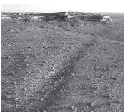
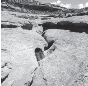
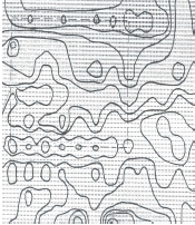
| Chaco Canyon Roads, Monumental Art or Agricultural Swales? As the photo on the left indicates, in many cases the constructed structures which have been identified as roads are, in fact, depressed swales. Investigation could determine if they were created to collect runoff from cryptobiotic soil which would naturally fertilize corn and other crops with soluble nitrates. I observe that if the Anasazi and others built structures that actually collect water, that is probably what they were built for. Stratigraphy and Palynology for the road swales has not been done so it is not known if corn was grown in these swales (Kincaid). A good example of a similar swale that may have been originally interpreted as a road and was later found to be a linear water collection basin is at the Mayan site of Peten. A thorough study of this proposal is certainly warranted. Cyanobacteria, previously called blue-green algae, are one of the oldest known life forms (Belnap). Summer monsoon storm events produce soluble nitrates when the rainfall passes through cryptobiotic soils and pours over canyon rims into Zuni gardens (Pawluk). Tom Huntsberger reports that during a field study, he did a pre and post thunderstorm nitrate analysis of an area in the Colorado Plateau where cryptobiotic soils are common, and found that subsequent to the rainstorm, the nitrate levels were dramatically higher. “Cryptobiotic soil crusts, consisting of soil cyanobacteria, lichens and mosses, play an important ecological role in the arid Southwest. In the cold deserts of the Colorado Plateau region (parts of Utah, Arizona, Colorado, and New Mexico), these crusts are extraordinarily well-developed, often representing over 70 percent of the living ground cover. Cryptobiotic crusts increase the stability of otherwise easily eroded soils, increase water infiltration in regions that receive little precipitation, and increase fertility in soils often limited in essential nutrients such as nitrogen and carbon” (Harper and Marble, 1988; Johansen, 1993; Metting, 1991; Belnap and Gardner, 1993; Belnap, 1994; Williams et all., 1995). I propose that in most cases “roads” are raised above the surrounding landscape to prevent ponding of water and protect the roadway from erosion during heavy rainstorms. Clearly Chacoan roads do not follow this worldwide norm. John Rooney, who supervised the phase two Chaco Road project, said he did not think the swales were built for transportation and communication. Rather, he felt it was some type of monumental art. He did indicate, however, that when he lost the “road” he was able to follow the plant litter as it created a dark line of organic material which collected at the bottom of the swale. He indicated that he had never heard of the cryptobiotic soil proposal but he did not see why they would grow crops so far from home. I suggest that nothing within a one hundred mile radius of any modern or ancient pueblo would be considered “far away” by the Tarahumara Indians and, I propose, by the Chacoans as well. Making fertilizer in Chaco Canyon - Slot Canyons, such as this one above Pueblo Bonito, collect soluble nitrates from rainfall on the surrounding cryptobiotic soils. One can easily observe the obvious female shape of what I believe are natural mixing basins (left). “After thinking about the Chetro Ketl field for thirty years, I am not at all convinced that it was an agricultural garden. The entire field was a series of basins approximately 4x5 meters each, comprising eleven acres in all. The soil is horrible, choked with calcium carbonate and sodium sulphate which created an impermeable water barrier” (preventing any root systems from developing). “These basins were sculpted or excavated out of the basement strata between the levies. The basins were coated with a clay layer that may have been from a flood event or the clay may have been hauled in and layered. Chaco Canyon was singled out as very poor farmland by the US Soil Conservation Service in 1936” (Loose). “I believe as the clay plastering was so finely bedded and evenly applied that this would not have been a natural overbank or flood event. The entire central section of Chaco appears to have been plastered and this field does not seem to be an exception” (Stein). I propose from this data that the Chetro Ketl field was not a “grid garden.” It was rather an ingenious design of fertilizer dehydration basins. I now question whether any significant agriculture was practiced in Chaco Canyon proper. I believe that the Chacoan elite controlled agriculture throughout much of the San Juan Basin by harnessing the unique topographical characteristics of dehydration basins that allowed for the exploitation of the fertilizer produced by the cryptobiotic soil. The Chacoans harvested and dehydrated the blue-green algae in the uniquely efficient basins in evidence at the Chetro Ketl field. I believe this dried fertilizer could be efficiently transported throughout the 60-100 mile Transhumance radius. While great logs and tons of corn were transported into the central canyon proper, I propose that fertilizer was being exported on the return trip. Combined with my Transhumance proposal, this fertilizer producing method would have given the Chacoans a visible means of support in this otherwise extremely harsh and inhospitable environment. In fact, evidence suggests this is why the Great Houses of Chaco Canyon were founded in this location. |
|||||
| Chacoan Swale. Permission granted Adriel Heisey |
|||||
 |
|||||
| Bluff Great House Road Permission granted Gene Stevenson, geologist, Bluff, Utah. |
|||||
 |
|||||
 |
|||||
| Topographic Analysis, Chetro Ketl field. Permission granted Richard W. Loose |
|||||
copyright 2005 - Richard D Fisher - DigitalTeamWorks.com