
Canyonlands of Mars
By Goro Komatsu
International Research School of Planetary Sciences
Università "G. d'Annunzio"
Pescara
Italy
Mars is a world of giants. Volcanoes towing 15 miles above the surrounding plains and flood channels hundreds of miles wide are just some examples of gigantic geologic landforms. Canyons are not exceptions. Valles Marineris is a rift valley system, which can be called the greatest canyonland in the Solar System.
The Valles Marineris system stretches 2500 miles, as long as the distance from Los Angeles to New York, and is deeper than 5 miles at some places (Figures 1, 2, 3). The gradients of the canyon walls can be in excess of 25 degrees in many localities. The widest part of the canyon system is over 350 miles. This magnificent canyonland was visible even from the Earth by telescopes as a dark lineation before the dawn of space exploration.
Following the earliest probes sent by the former Soviet Union and the United States, Mariner 9 arrived at Mars on 14th November 1971 and began imaging the surface. After 3 months of a global dust storm that obscured the view of the vidicon camera onboard, the Mariner 9 revealed a wide array of surface landforms never seen before by human eyes. Among them, the vast canyon system of Valles Marineris. The canyon system was named after the Mariner 9 spacecraft indeed.
Clearly Valles Marineris has a tectonics origin. Its formation resembles those of terrestrial rift valleys such as the East African Rift Valley and the Baikal Rift system. Although there are observations indicating involvement of water in the evolution of Valles Marines, we still need confirmation on this point.
There are other canyons on Mars. Among them, Loire Valles are worth mention. Vallis (valles – plural) means valley, but the scale of Loire Valles is similar to that of the Grand Canyon in Arizona. The Loire Valles system is centered at about 20 ° S latitude, 16 ° W longitude in the Margaritifer Sinus region (Figures 4, 5). It is about 440 miles long and begins as a narrow outflow channel at a small region of chaotic terrain where grounds appear to have collapsed forming deep jumbled holes. The width of the channel varies from less than a half mile to about 3 miles. However, along most of its length it is heavily dissected by numerous tributaries, sections of which head at escarpments similar to those at the Grand Canyon of Arizona. The width of canyons between the escarpments varies from about 25 to 60 miles. In contrast, the Grand Canyon is about 300 miles long and 13– 45 miles wide. The Grand Canyon is as deep as about one mile, Loire Valles are as deep as about a half mile.
Another example of prominent Martian canyons is the Nanedi Valles system that is a collection of smaller valleys compared with Valles Marineris and even with Loire Valles. It is centered at about 5 ° N latitude, 48 ° W longitude in the Xanthe Terra region. These valleys have been cited often in the Mars science literature as the one of the best examples of landforms formed by flowing water on the surface sometime in the past. Note that Nanedi Valles system's meandering paths (Figure 6) display a complex pattern ofcutoff meanders and paleochannels. This type of pattern is commonly observed with terrestrial analogues. Patterns of paleochannels on Earth are often attributed to changes in discharge rate, climatic shift, and neotectonics, implying that Mars also experienced such changes.
The rapid advance in robotic technology may someday make the visit to the canyonlands feasible. For example, NASA ( National Aeronautics and Space Administration) has been considering to send an airplane to fly over Martian surface and conduct a regional survey. It is a quite appealing idea. Imagine flying by canyon walls in excess of 5 miles! Considering the sizes of canyons on Mars, a flight apparatus can provide a fast and efficient way to investigate a vast territory. Ballooning is another option. Canyons are interesting targets for ballooning since positioning instruments on a high steep cliff is difficult for conventional approaches such as rovers moving on the surface. In contrast, balloons can traverse a wide swath of canyon walls with ease.
Space agencies such as NASA and ESA (European Space Agency) are focusing on astrobiology lately. In pursuit of search for life on Mars, “Follow the water” has become the prime theme in the recently conducted and also planned future robotic explorations. This means that any landforms linked with past and current water processes are the potential targets for investigation. Both Valles Marineris and other smaller canyonlands, therefore, have a high chance for visits by those robots.
How about the human exploration to Valles Marineris and other canyonlands of Mars? This will eventually happen but the question is when. Exploring the great canyons on Mars by humans could provide stunning images of natural beauty exist on Mars. Maybe you will be lucky one to see them with your own eyes!
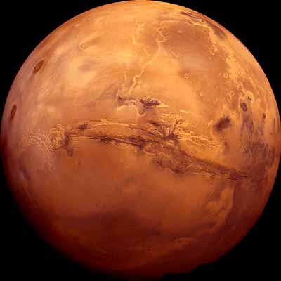
Figure 1. The 2500 mile-long Valles Marineris system on Mars. Viking image mosaic. Image credit United States Geological Survey.
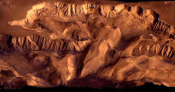
Figure 2. 3-dimensional perspective view of Ophir and Candor Chasmata, central part of the Valles Marineris system. Viking image mosaic. Image credit Jet Propulsion Laboratory/ National Aeronautics and Space Administration.
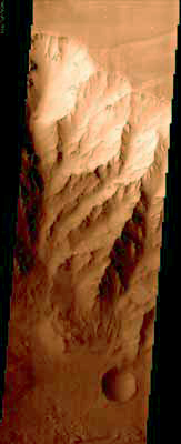
Figure 3. This high resolution Mars Orbiter Camera image shows 5 mile high walls of Coprates Chasma, part of the Valles Marineris system. Image credit National Aeronautics and Space Administration/Jet Propulsion Laboratory /Malin Space Science Systems.
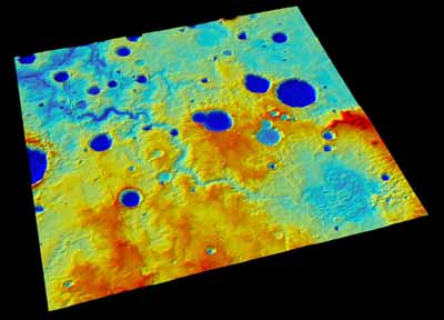
Figure 4. 3-dimentional perspective image of Loire Valles. The width of canyons between escarpments varies from about 25 to 60 miles. Vertical exaggeration 5.
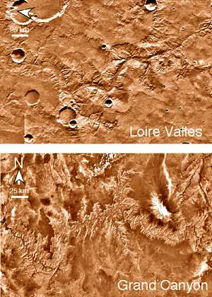
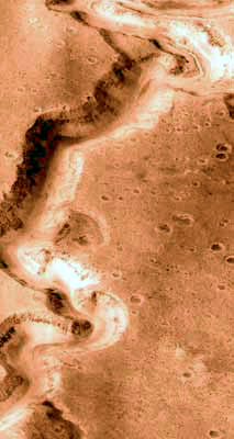
Figure 6. This high resolution Mars Orbiter Camera image (about 6 miles across) clearly indicates a complex history of Nanedi Valles. Image credit National Aeronautics and Space Administration/Jet Propulsion Laboratory /Malin Space Science Systems.
Canyonlands Website - (with full navigation links)
without navigation
Tibet | Africa | Paquime | Tepui | Australia | Mogollon Rim | Copper Canyon | Europe | Mars | Crystals