The Grand Canyon of South Africa
Located in Augrabies Falls National Park
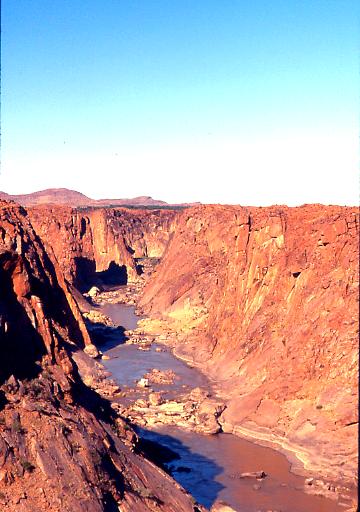
The Orange River drops 191 metres at the Augrabies Falls. The thundering cascade of water led the original Hottentot residents to believe that evil spirits were active here, and so they named the waterfall Ankoerebis, "place of big noises", from which the Trek Boers, who settled here later on, derived the name Augrabies.
Especially in late summer, when the river carries a lot of water, the roaring waters fully justify that name. New waterfalls then form at the sidewalls, and the air is filled with dense spraying fog. The gorge at the Augrabies Falls is 240 m deep and 18 km long. It is a most impressive example of granite erosion. When the whole landmass of the area lifted about 500 million years ago, the Orange River slowly started to dig its bed into the ground.
The Augrabies Falls National Park, an hour from Upington, comprises an area of 820 sq km and stretches along the Orange River. The vegetation is suited to the arid desert climate. The Kokerboom, or Quiver Tree grow here. They are succulents and can store huge amounts of water in their stems and so survive long periods of drought. The park contains a game reserve with rhinos as the main attraction.
December 2004
The first comprehensive guidebook to
canyons worldwide available.
Sunracer Publications
P.O.Box 86492
Tucson AZ 85754
(520) 882 5341
sunracer@theriver.com
The national park has three general botanical regions. The lower slopes have been cultivated and grazed, while the alpine regions (up to 3600m) were forested, although much has now disappeared. The higher lands are mountain grasslands with fescue grasses as well as heathers, splendid Red Hot Pokers and Giant Lobelia.
Home | Ethiopia and Namibia | Ethiopia | Simien | Map | Fish River | Namibia | Augrabies | Photos
Canyonlands Website - (with full navigation links)
without navigation
Tibet | Africa | Paquime | Tepui | Australia | Mogollon Rim | Copper Canyon | Europe | Mars | Crystals