Canyonlands of Ethiopia
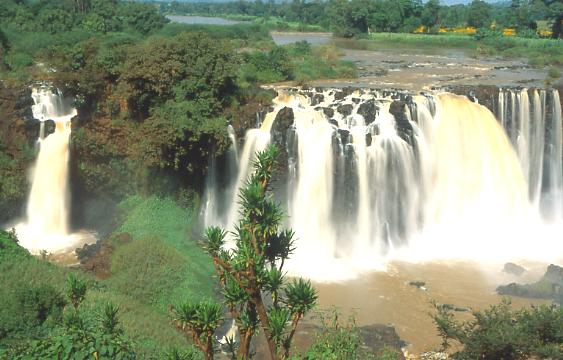
The river Nile, over 800 km in length within Ethiopia and the longest river in Africa, holds part of its heart in Ethiopia. From Lake Tana, the Blue Nile, known locally as Abbay, flows to meet the white Nile in Khartoum, to form the great river that gives life to Egypt and the Sudan. It has been said that the Blue Nile contributes up to 80% of the Nile?s flow. Nowhere, is it more spectacular than where it thunders over the Tisisat Falls, literally "Smoking Water" - near Bahar Dar. Here millions of gallons of water cascade over the cliff face and into a gorge, creating spectacular rainbows, in one of the most awe-inspiring displays in Africa.
The Blue Nile falls can easily be reached from Bahar Dar. Some 225 km from Addis Ababa, the Blue Nile Gorge can be enjoyed as part of an excursion from the capital.
The Ethiopian History: History Ethiopia has a long history, going back to the legendary Queen of Sheba. Imperial rule continued through the reign of Emperor Haile Selassie and ended in 1974 with the seizure of power by the Derg, a military council that transformed itself into a communist dictatorship. The Derg ruled the country until 1991, when the Ethiopian Peoples' Revolutionary Democratic Front (EPRDF) deposed it and established a transitional government. In 1995 a new constitution that ensured democratic rule was adopted. The EPRDF has governed the Federal Democratic Republic of Ethiopia (FDRE) ever since.
Topography: The country has rugged topography featuring the vast central highlands separated from the eastern highlands by the great rift valley running from the northeast to the southwest.
Altitudes: Altitudes ranges from 110m below sea level at Dallol in the northeast to over 4,600m on the Semien Mountains in the northwest.
Ethnic groups: Culturally and ethnically diverse, Ethiopia's population is composed of about 80 ethnic groups. The Oromo and the Amhara are the dominant ethnic groups, jointly accounting for 61% of the total population
Infrastructure and utilities:
Seasonal Variation: Travel to most of Ethiopia's favorite sites is possible by land or air all year around. However, the rainy season, which usually starts about April and ends about May, can make some areas in the southwest difficult to visit because of road conditions. This includes the Omo river valley and other nearby tribal areas.
Currency exchange: The Euro, US dollar and major traveler's checks are easily convertible in banks and some hotels. ATM's are not in use.
Language: The official language is Amharic, but English is widely spoken in major hotels, in the banking and travel industry, in up-scale shops in cities, and in Medical facilities.
Telecommunication: The telephone is widely available throughout the country. The Internet is available only in large cities.
Air travel: Ethiopian Airlines is a major international air carrier and the largest African Airline. It offers convenient service from the United States, Europe and Asia. It provides domestic and international air service between Ethiopia and other countries. EAL has a good safety record and is one of the few profitable African airlines. EAL also provides training and maintenance to more than a dozen African and middle eastern airlines.
Hotels: All hotels on our tours are the best available and compare favorably with western standards of service, facilities, and hospitality.
Contact information: redjackal@telecom.net.et
Thanks to http://www.redjackal.net for their help
(with permission of Yohannes Assefa)