Fertilizer and Crop Production
Soil Productivity
The first issue to consider is soil productivity, which is affected by the following three factors:
Fertility of the parent soil type
Orographic lifting
Pest control
In a 1988 soil analysis done by Robert H. Schmidt, Jr., Ph.D., and Rex E. Gerald, Ph.D., they state (1988:165, italics added):
The occurrence and distribution of water-control devices in the northern Sierra Madre Occidental can be explained on the basis of the soil’s parent material and, to a lesser extent, by the seasonal distribution of precipitation . The area at the northern and western extremes of the Sierra Madre are associated with andesite surface rock which weathers more rapidly and produces a more fertile soil than the rhyolite-derived soils found to the east and south. A more even distribution of moisture occurs on the western, or Sonoran, side of the continental divide than that associated with the Chihuahuan Desert regime on the east. Thus, more moisture is available for agriculture during the growing season on the western slope . My investigation indicates that water-control systems were constructed by local groups to increase agricultural production on sloping land and were not part of a massive, but incomplete, project to protect irrigated fields downstream, as contended by Di Peso (1974).
Andesite and rhyolite are both fine-grained volcanic rocks that were formed during the Tertiary Period; andesite is richer in iron and magnesium than rhyolite, however, and produces greater soil fertility (Schmidt and Gerald 1988:170). According to Schmidt’s theory, which he proposed at the Department of Geological Sciences, UTEP, the extensive agricultural terraces in the northern Sierra Madre were based on soil fertility, which comes from the parent geological strata and from the dramatic orographic lifting caused by the canyons of the western Sierra Madre . As related specifically to geological parent soil resources, this terracing phenomenon is also apparent in the Gila and, to a lesser degree, at Mesa Verde.
Given that the terracing system is the largest known Paquimé/Anasazi construction, Schmidt’s theory provides an important and significant foundation for it. (See Figures 1a-1c.) The terracing system represents many hundreds of thousands of man-hours and may be equal in terms of necessary labor to all of the other known Anasazi architectural constructions combined. It certainly indicates a considerably greater investment in labor than all of the buildings at Chaco Canyon . Using a natural systems model , it is also clear that the widespread use of agricultural terraces represents one of the most important Paquimé/Anasazi cultural contributions and highlights the central role of agriculture throughout Oasis America .
As pointed out by Schmidt and Gerald (1988:168), virtually all water control features, i.e., terraces, found in the northern Sierra Madre Occidental occur below 2,000 m, where there are at least 160 frost-free days. The importance of elevation is also shown at Chaco , where the location of the outliers clearly indicates that elevation played a more important role than soil type in determining where outliers and their associated agricultural fields were situated. At optimal elevation, the beneficial effects of increased rainfall due to orographic lifting were felt; in addition to more rain, there were also at least 160 frost-free days, along with hard winter freezing and heavy snowfall. These conditions provided natural pest control, primarily, in the case of corn, of root cutworm.
Fertilizer
In addition to inherent soil productivity, rainfall from orographic lifting, and elevation-enhanced pest control, the issue of fertilizer must be addressed. Was it produced, and if so, how? How was it used?
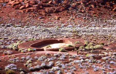
Wupatki Female Fertile Rain Magnet
This Sweetwater Mulching Reservoir is the bridge between Anasazi and Hohokam culture groups. The double masonry walls around this architectural feature share many characteristics of the Mummy Lake reservoir at Mesa Verde in that high sugar content corn could have been grown between the supporting walls. The shape is reminiscent of the previously misidentified Hohokam "ballcourts." Wupatki has many pre-Anasazi reformation AD1275 characteristics while the archaeological evidence indicates a pilgrimage and trade zone for both Anasazi and Hohokam cultural groups. Wupatki also has a strong Mesoamerican connection as the Sinagua area had 53 Scarlet Macaws uncovered and Wupatki had more than any other site north of Paquime.
The geographical placement and shape of this Wupatki feature is the "Rosetta Stone" for unraveling the Hohokam "ballcourt" mystery as well as a major piece in clarifying the agricultural, architectural, and cultural puzzle of Oasis America. This anthropomorphically correct shape is the receptacle of fertile male sky god liquid or monsoon thunderstorms which have a measurable quantity of "fixed nitrogen" and is specifically beneficial for the growing of corn during the C4 period of explosive growth.
Across pre-Columbian North America , water features have been found that have perplexed archaeologists for years. From Mummy Lake , Colorado , to the (“ballcourts”) of Wupatki and Pueblo Grande , Arizona , and to the extensive lakes and wells of Paquimé, these structures have been an ongoing mystery. Thousands of artificially constructed water and organic debris catchment basins dot the landscape from the Hohokam and Anasazi in the north to the Aztec and Maya in the south. Our unique proposal is that the Paquimé/Anasazi cultures and indeed all major complex Native American cultural systems from Mesa Verde to the Yucatan built public architecture that was used for the institutionalized production of fertile water (gray water) and mulching material used on the cornfields associated with these artificially constructed basins. I propose that the Hohokam “ballcourts” are in fact catchment basins for rainfall. In other words, these water features represent a well-planned and carefully constructed system of “sweetwater mulching swamps” whose purpose was the production of fertile sediment.
I also propose that the sweetwater mulching swamps were specifically designed to catch monsoon rainfall that contains “fixed nitrogen” that is useable by plants. This specific type of rainfall is caused by the electrical discharges associated with these seasonal storms.
The scientifically incorrect term for this “fertile rainfall” used by gardeners and horticulturists is “ionized rain.” Rain falling during a thunderstorm will contain a greater concentration of dissolved inorganic nitrogen compounds (“fixed” nitrogen) than rain falling when there has been no lightning. All plants require inorganic nitrogen compounds for growth; atmospheric nitrogen (and organic nitrogen compounds) cannot be used directly by the plant. So, rain falling during a thunderstorm will “fertilize” the soil better than rain falling when there has been no lightning.
Ethnographic reports by the gentile Tarahumara indicate that rainfall accompanied by lightning comes from the “male” Tata Dios and everyone knows, so “it goes without saying” that it is more fertile than normal rainfall. Gentile Tarahumaras report that the male (½) sky sends down his (semen) during intercourse with the female (½) earth. These Tarahumara relate that they are the “children” of god and see the relationship between the earth and sky including the act of intercourse in a very anthropomorphic way. There are not two gods, but rather a father and a mother which are unified as one god. They do recognize that each half of the whole has unique characteristics. Life can only originate from the whole. Everything in the universe is explained as a whole with various characteristics as a part of the male/female, or in their view, the female/male relationship. Once this very simple concept is understood, much of the religious, environmental, agricultural, architectural, and artistic designs can at least in part be deciphered and interpreted by modern scientists. (The gentile Tarahumara are a group of extremely isolated indigenous non-Christian people who have never had a government school in their village region. This location is in west central Chihuahua on a roadless spur of the Sierra Madre Occidental . They take pride in having never been Christianized and are extremely independent and relatively hostile to the very few foreigners that venture into their extremely rugged canyon homeland. They are called “gentile” by their surrounding Christian Tarahumara and Mestizo neighbors. I am one of perhaps three college educated persons that has been able to establish a long term friendly communication with these folk over the past twenty years.)
At least nine percent of all naturally occurring “fixed nitrogen” comes from thunderstorms. Based on this scientifically correct ethnographic report, I will use the term “fertile rainfall” to refer to this critically important phenomenon.
In addition to fertile rainfall, the other two types of naturally occurring inorganic nitrogen compounds found in nature are caused by cyanobacteria (and other bacteria) as it breaks down organic material. The third type of biologically useful nitrogen is supplied by legumes such as mesquite. I propose for further study that the Hohokam “ballcourts” used compost material including human and animal waste, as well as mesquite bean pods, pollen, flower and leaf materials to be broken down by bacteria in the mulching swamps to produce a very potent liquid mixture of fertilizer. The unexcavated half of the large Snaketown “ballcourt” and other similar depressions would provide a perfect test area for this proposal.
Organic material, from plants, animals, and humans, and charcoal were then added to the fertile rainfall, which, in the heat of the summer sun, produced an organic gray water solution used to fertilize the corn at the specific C4 genetic characteristic inherent in the corn growth cycle. As a result of fertilization, the corn had increased sugar content; this specialized corn was used in religious ceremonies.
It is possible to determine whether corn has been fertilized by the size of the cob and the corn kernels. Such studies have been done in Mesoamerica but not yet in relation to Oasis America . I believe this represents an important direction for future research as well.
My sweetwater mulching swamp proposal has recently received substantial support from a major new archaeological analysis of the ancient site of Mummy Lake , in Mesa Verde National Park . This feature’s use was previously unknown, though it has been surmised that it might have been a dance floor, an extremely large kiva, or even a reservoir for irrigation water. Mummy Lake is a shallow pond, about 100 feet in diameter, with an “early intake system.” What is unique is that two, possibly three, stone walls surround the pond area. Recent research by Kenneth Wright, P.E., a specialist in paleohydrology, demonstrates that this was unquestionably a reservoir. Wright’s research team found deposited sediment between the two walls, which they assumed was simply waste or excess material taken out of the reservoir. They also found that this sediment was layered with large quantities of corn pollen. Corn pollen does not blow very far and tends to drop directly to the ground. The unmortared rock walls that defined the edge of the pond would have helped to sub-irrigate the cornfield that surrounded the water; it is easy to imagine a lush, green 20-foot wide garden with corn, beans, and squash surrounding this small pond. I propose that what has been discovered is a sweetwater mulching swamp that was a major designed construction by the Anasazi. As with the other cases in my study of complex Paquimé/Anasazi/Hohokam agricultural strategies, such an interpretation in my view is not only possible, but probable.
In most known cases, a large number of potsherds associated with water transport ceramics have been found near Paquimé/Anasazi water features. These specific utensils were items of high religious significance and were used to apply the fertile water to the fields. In the Mummy Lake excavations, of more than 2,500 sherds collected, 86 percent are jar forms and 87 percent are white wares (Wilshusen, Churchill, and Potter 1997:674). In addition to jar forms, the potsherds also come from ladles (1.1 percent) and bowls (12.4 percent) (Wright 2000:43); this is similar to the potsherd distribution found by Smith and Zubrow in 1967 at Morefield Reservoir. The type and distribution of potsherd shapes imply that Mummy Lake was a specialized use structure (Wright 2000). At the Woods Canyon Reservoir, too, the very high percentage of white ware jars and low percentage of gray ware utility ware sherds strongly indicate a special use site rather than a habitation site (Wilshusen, Churchill, and Potter 1997).
The primary background data for my proposal regarding public architecture used to produce fertile water came from Richard H. Wilshusen, Ph.D., Wright Paleohydrological Institute, Vernon Scarborough, Ph.D., and Charles Di Peso, Ph.D.
At Chaco Canyon , evidence is found in the abundance of cattails and the construction of “rincons” in the archaeological record. Along with the great number of cylindrical ceramics that may have been used to transport fertile water to the grid gardens and fields, these rincons at Chaco Canyon are a prime candidate for the sweetwater mulching swamp concept. On the Pajarito Plateau there are numerous large ‘U’ shaped reservoirs or water catchments that remain unexplained. Evidence provided by C.D. Allen of the US Geological Survey also suggests that these late phase classic pueblo features may have been enhanced by water collection from rooftops and plazas. As indicated by some of the Mayan reservoirs, water catchments from plazas and living areas such as rooftops were very likely gray water resources and not used for drinking water. At Paquimé, there are numerous probable gray water reservoirs and wells. Charles Di Peso provides evidence that the House of the Well had two full bison and numerous other animals interned in the cistern in the center of town. From the Di Peso Paquimé map numerous reservoirs are constructed adjacent to mounds. Other identified cisterns, reservoirs, or ponds are the termini of drains that pass through residential areas as well as locations where animal waste products might be found, such as House of the Macaws. It is clear that the water system at Paquimé passes through virtually all areas of the town. Many of these have been identified as sewage drains. These drains all end in some type of identified water retention basin. It appears that most if not all of these basins, reservoirs, wells, ponds, and cisterns probably collected gray water for production of fertilizer. For further research some of these wells were community resource locations, and others may be associated with family or clan ownership.
From Paul Fish, Ph.D., I received evidence that modern Pima as well as other cultural groups use the detritus, along with legumes, to enhance soil fertility. Using my natural and human systems model , my 2002 interpretation of sweetwater mulching swamps represents the first known proposal that detritus was used in an organized way by the Paquimé/Anasazi/Hohokam cultures.
Taking my interpretation one step further, I propose that all Hohokam/Paquimé “ballcourts” should now be re-evaluated as potential sweetwater mulching swamps (see Figure 2). Many of the smaller courts appear in clusters and in association with agricultural activities, presenting a high probability that the Hohokam were using the same type of fertilizer-producing water features as the Anasazi and Paquimé. All courts that were not constructed to naturally drain after rainstorms and from which organic sediment is being removed during periodic cleaning were most likely constructed as specialized agricultural enhancements.
In addition, I propose that, regardless of size, all ballcourts that collect rainwater during the monsoon season should be re-evaluated in light of the mulching swamp concept. Hohokam and some Paquimé ballcourts have topographically depressed centers, raised oval sides, and floors that were sealed with caliche or other material so they would hold water.
The shape of the Hohokam “ballcourt” has long mystified archaeologists, as it does not conform to any of the other known ballcourt designs from pre-Columbian North America . Again using the gentile Tarahumara interpretation of female/male religious system, the “ballcourts” when viewed from the sky are the universal symbol of female fertility. This shape might be interpreted as an architectural design by the Hohokam to attract the fertile rain to the specifically appropriate shape constructed in the mother earth. This may also explain why some of the more dramatic “ballcourts” are associated with platform mounds. (The early Spanish went to great lengths to suppress this universal female religious design pattern. Natural systems and the female aspect of the universal paradigm is not a part of the European belief system. This religious symbol reemerged quite dramatically in the well known Virgin of Guadalupe, which contains some of the readily-identifiable elements including the aura, labia and is included with the Spanish bull horns. While indigenous people see the complete shape of the female goddess with the Native American (correct) skin color, it is accepted as the representation of the “virgin” which is a Roman Catholic Christian cameo.) I propose for further study that these two elements be reevaluated as a “wholistic” ceremonial religious complex.
Also, “macaw stones” – the uniquely shaped doors to the macaw pens found at Paquimé – are associated with the numerous regional Paquimé ballcourts. Yet, Scarlet Macaws are specifically associated with water control. Why, then, would macaw stones be found in ballcourts, a highly unlikely location for water control apparatus? Macaw stones were fashioned with a great deal of attention to detail and significant investment in labor, and it is clear from their design that these doors could also be used as intake or outlet valves for water features. I propose, therefore, that many of the so-called Paquimé ballcourts are actually water retention features related to the production of fertile (gray) water. Further, if some Paquimé ballcourts were in fact water features, then it is plausible that some features in the Hohokam area currently identified as ballcourts could also be water features. This original analysis provides a viable alternative to the current practice of identifying any feature with an elongated or oval shape as a ballcourt.
In summary, the general characteristics of sweetwater mulching swamps include the following:
Topographically centralized depressions behind one or two oval or circular dams of masonry or earth
By design and function collect rainwater from a relatively limited area or catchment
Hold water for a short period of time, especially as associated with monsoon weather patterns
Stratigraphically demonstrate a distinct layer of organic material above a floor sealed with plaster, adobe mud, or caliche
Often associated with sherds of water transport vessels of high quality and design features
Located near towns (Anasazi/Paquimé) or habitations with a closer water supply of higher quality or quantity
Also found in predominantly agricultural resource areas not closely or directly associated with known towns or habitations (Paquimé)
It has long been a mystery why the Oasis America cultures chose sites that were not associated with the major sweetwater streams and rivers of the region. I propose that it was not specifically water they were interested in exploiting, but rather a system of fertility that is not clearly understood currently. The gentile Tarahumara report that it is fertility and rainfall taken together that is the focus for their agriculture. They report “it goes without saying” that rainfall is of little value without fertility and that fertility is of little value without rainfall. In their religious view only the two halves constitute the whole.
One of the big questions in archaeology is: Why did the Hohokam build the largest irrigation canal system in the western hemisphere? I propose a completely new paradigm for the comprehensive reinterpretation of this dramatic human effort. Using the “natural and human systems” interpretation, I propose that the Hohokam canal system was constructed to irrigate a vast bosque of mesquite trees. These trees provided in equal parts the essentials of food, fuel wood and charcoal, building materials and soil fertility, as mesquite is a nitrogen-fixing tree or legume. It can also be speculated that this forest actually created a microclimate of moderate temperatures as well as increased humidity. John P. Andrews and Todd W. Bostwick speculate on the disappearance of the Hohokam in their book, Desert Farmers at the River’s Edge. Here they make reference to the problem of salinity, yet dismiss it, saying, “The fact that the Hohokam practiced irrigation agriculture successfully for more than 1,000 years indicates that they had addressed this problem [of salinity].
In a comprehensive survey of experts on western rivers, I have noted that the Salt River salinity historically remained somewhat consistent as the salts come from specific geological sites or salt beds that have not changed to any dramatic degree in the past 2,000 years. I also found that the Salt River (1,100 mg/L) is almost five times as salty as the Rio Grande near San Ildefonso (196 mg/L), the Chama River at Chamita (187 mg/L), and twice as salty as the Colorado River at Lees Ferry (538 mg/L). It has been noted for years and verified for this report in the references that beans are very salt sensitive and that corn is moderately salt sensitive, scientifically contraindicating the extremely saline Salt River as the major source of water for these crops. I propose for further study that a new direction of research for the purpose of the extensive Hohokam canal system is this mesquite bosque proposed.