Transhumance: Across Ground Daily, Weekly, Seasonally
Recent research by Michael E. Whalen and Paul E. Minnis (2001) on the Paquimé “zone” pattern of settlement provides the details of a “transhumance” settlement strategy, although they do not interpret the data in this manner. The transhumance interpretation has not been widely accepted as daily, weekly, or even seasonal agricultural strategy; however, Whalen and Minnis have gathered data that strongly indicates a Paquimé pattern of transhumance distance zones. In my analysis, the inhabitants of Paquimé’s Casa Grande pueblo had one or more homes of varying sophistication, in addition to their main residence in town; these additional homes were within the central zone and perhaps also in the outer zones. Using my natural and human systems model , my theory is further supported by the transhumance practices of today’s Tarahumara Indians.
Transhumance/seasonal migration is a concept originating from French and Latin roots (trans=across, humus=ground) and means, literally, “across ground.” While the term is applied specifically to Central Eurasian herding cultures, it also can be applied to Oasis America cultures as they moved across the landscape planting corn throughout a regional area. As there is a very contentious debate about the semantics of this word, I would recommend that two options be considered. The first option is to have listed in the dictionary (1) the European definition which refers to the Eurasian practice of following herds from winter to summer pastures and (2) the new world practice of moving seasonally from two designated homes for the purpose of planting crops. The second option would be to use the very simple and direct terminology applied by the gentile Tarahumara. The term that is used is “cambio nivel” or translated to English “change of level.” (Currently, I do not know the Tarahumara Uto-Aztecan word root for this common practice and as such it remains a topic for future research.)
Vernon Scarborough, Ph.D., and numerous other archaeologists have published findings that pueblos in Oasis America planted widely across their territory and that central pueblos (such as Chaco Canyon ) had low population densities during the growing season. Transhumance is also accepted by Grand Canyon and Glenn Canyon archaeologists, while the concept of “task groups” is widely accepted for the Mesa Verde/Yellow Jacket/Crow Canyon region.
In the Grand Canyon , the relationship between the plateau and the canyon has been studied in depth by Douglas W. Schwartz, Jane Kepp, and Richard C. Chapman (The Walhalla Plateau 1969). They state that above average rainfall beginning about AD 1040 must have made the Walhalla Glades (canyon rim habitations) eminently suitable for farming by AD 1050. “In response, small field houses associated with artificial terraces, garden plots, and check dams began to appear in every area in the Glades” (1969:125). Archaeological evidence, such as a scarcity of hearths, indicates the Walhalla Glades were occupied only in the summer and early fall, while excavated sites in the canyon uncovered large quantities of artifacts, suggesting that these sites were occupied fairly continuously. “They could easily have been the permanent homes of the farmers who cultivated crops during the summer in the Walhalla Glades” (1969:130). Also, no kivas have been found in Walhalla Glades while four have been excavated in Grand Canyon , again easily explained by short-term habitation on the plateau and more permanent habitation in the canyon. Looking at pottery remains, the plateau and the canyon were “obviously part of a single ceramic tradition because they produced exactly the same wares and types” (1969:131).
In Glen Canyon , an excellent case for seasonal migration is made by Paul V. Long (Archaeological Excavations in Lower Glen Canyon, Utah, 1959-1960 1967). He proposes that prehistoric people, living permanently on the highlands to the south of Glen Canyon , particularly Cummings Mesa, utilized Lower Glen Canyon on a seasonal basis for farming and gathering raw materials for tool manufacture. Citing Lipe (1960:43-67), Long says there is little evidence of permanent occupation in Lower Glen Canyon except at Talus Ruin. Also, an extensive trail system links river sites on the left bank with known pueblos on Cummings Mesa; during the ceremonial cycle, people farming the river terraces could have used these trails to return easily to their home pueblos for religious rites. In all, the bulk of evidence gathered from the 39 excavated sites in Lower Glen Canyon indicates seasonal habitation there. “…for the most part, the sites on the left bank and many on the right bank are primarily seasonal homes of people planting and harvesting crops on the river terraces and bars along the Colorado River in Lower Glen Canyon” (1967:68).
The pattern of burials documented in Glen Canyon , Grand Canyon , Chaco Canyon , and at Mesa Verde provides additional, key support for my Oasis America transhumance/seasonal migration theory. Only four burials have been found in Lower Glen Canyon , while burials in the highlands are relatively numerous (Long 1967); in Grand Canyon , the opposite is true: there is a paucity of burials on Walhalla Plateau and there are many burials in the canyon bottom (Schwartz, Kepp, and Chapman 1969). In both cases, the findings corroborate shorter seasonal habitation where there are few burials and more permanent habitation where most burials are located. At Chaco Canyon , few burials have been found in relation to the number of great houses (Noble 1984), indicating Chaco ’s function as a special use storage, ceremonial, and winter habitation center. At Mesa Verde, too, there are relatively few burials at the site itself, suggesting its use as a seasonal summer residence rather than a permanent habitation. In my analysis, a paucity of burials and short-term seasonal residence clearly go together, as do an abundance of burials and longer-term, primary habitation.
At Chaco , the outliers were well within the documented transhumance range. Based on natural and human systems , the concept of outliers is easily applied to the newly discovered Sky Island Paquimé culture site, as well as to the numerous other Paquimé sites. As these Paquimé sites fall into the same distance range as similar sites at Chaco , they could justifiably be called Paquimé outliers. This analysis reflects similar archaeological theory denoting Chaco and Paquimé as special cultural phenomenon that might be considered an extended “city-state” political system. Such special status aspects of Chaco and Paquimé are held by many archaeologists, most notably Charles Di Peso, Ph.D., and Steve Lekson, Ph.D.
Perhaps to facilitate transhumance movement, Chaco architectural design provides for “exterior doors on the back sides of great houses which indicate that these rooms could have been road related” (Strutin, 1994:45, italics added). “Perhaps,” her hypothesis continues, these rooms “were meant for storing goods that came in from outlying communities” (Strutin 1994:45). Our alternative theory proposes that these rooms could also be interpreted as providing shelter for agricultural social elements during seasonal visits to the Canyon , or, in other words, a form of transhumance housing support structure. In a worldwide context, historical as well as current, rooms fronting on a road usually provide shelter for travelers or visitors, not for goods that are important enough to store. Specifically at Chaco, agricultural produce and other valuables that had perhaps been carried great distances would be stored in interior spaces, where security was assured by the exterior three to four story high masonry stone walls, while accommodations for people in transit but not part of the extended family would be assured through the basic pre-planned architectural design.
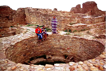
Transhumance agriculture is strongly supported by the large, extensive granaries found at sites such as Pueblo Bonito and the Sky Island culture site. In the Paquimé culture region, corn was widely grown throughout the area, dried, and transported to Paquimé itself, approximately 75 miles from the Sky Island site.
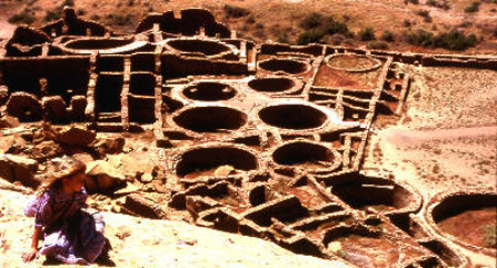
Pueblo Bonito Chaco Granary Row
In expanding on what is known about the Paquime granary system through in-depth review of scientific and archaeological evidence, I am proposing that the key hole granaries of Pueblo Bonito in Chaco Canyon, Cliff Palace at Mesa Verde, and many other areas were in fact granaries prior to approximately AD1275. During this time period the religious basis for the desert canyonlands changed as the Katsina religious concepts became the dominant religion. I am proposing based on the research of Robert M. Adams that this bank of Pueblo Bonito keyhole kivas are actually functional smoker granaries. It is proposed that after the 50 year drought beginning in AD1130 that all the stored corn in these granaries was consumed and residential and other activities occurred in these rooms until the abandonment of Chaco in AD1140-1175. I am proposing that religious activities at Pueblo Bonito were conducted on the platform mounds in front of this structure. I am proposing for further study that all kiva chambers prior to AD1275 were used as functional facilities for food storage, the preparation of penole and/or teswino corn beer. As these food preparation events were highly significant religious feasting ceremonies, these round rooms later became the kiva religious chambers as might be expected.
Today many archaeologists may have perhaps forgotten the "Katsina reformation" in AD1275 when interpreting features in Chaco, Aztec, and Mesa Verde among others which predate this very important shift in Anasazi religion, trade, and politics. Many of the Chacoan features are interpreted using modern Hopi ceremonial traditions which reflect an indigenous movement against the Mesoamerican traders which is thought to have originated along the upper Little Colorado River during the 13th century.
I am reinterpreting Chacoan architecture from perhaps what might be the original utilitarian purposes
Concisely, it is also significant to note that in our timeline date of AD1275 the Katsina religious followers ejected the Mesoamerican diety cult/traders. From AD1200-1275 the Macaw traders were prohibited from entering the Anasazi area. In AD1280 the Kayenta Anasazi moved into the Point of Pines. In AD1250 Paquime was founded. The Kayenta Anasazi were burned out of the Point of Pines and moved south to participate in the San Pedro River, Arizona culture areas. Many archaeologists believe that the Mesa Verde/Aztec/Chaco Canyon Anasazi moved south to join Paquime in AD1270-1290.
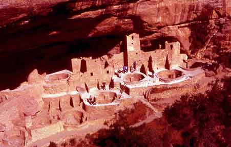
Cliff Palace Mesa Verde Granary Row
The design of Chaco Canyon keyhole kivas continues from AD1150 to AD1270 at Mesa Verde and many other sites. I have done extensive testing on the keyhole kiva design and have found that if the chamber is closed it becomes an extreme hazard or death trap for carbon monoxide poisoning if there is a fire or coals inside. This would indicate an affective strategy for pest control during corn storage and would contra-indicate human usage under these specific conditions. As in the case of Chaco/Mesa Verde keyhole kivas the grain would have been completely consumed during drought conditions prior to abandonment of the sites. Even if the site was abandoned for reasons other than drought, it is very likely that all edible materials would have been consumed or moved. It can also be proposed that clan related farmers moved in to the empty chambers that were no longer serving their primary intended function as the outlying areas became more dangerous and indefensible during times of well documented strife and warfare. Archaeologists generally agree that there was a reduction of population to the main centers during times of drought and subsequent social strife. It would follow that chambers used for storing corn in times of plenty and social harmony would be converted to living quarters during times of food shortages and consequent social chaos apparent in the archaeological record. Chaco and Mesa Verde were abandoned pre-Katsina cult which is approximately AD1275. I am proposing that after that time these smoker granaries were very logically converted into the religious kiva chambers that are understood today. I propose that the religious system prior to AD1275 reflected much more Mesoamerican characteristics and was very different than the Hopi and Pueblo Katsina religious system of the modern era. Paquime was the exception until AD1425-AD1575 when it too was attacked and abandoned.
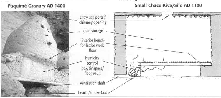
Paquime Granary AD 1400 |
Small Chaco Kiva/Silo AD 1100 |
The gentile Tarahumara report another most critical agricultural reason for the transhumance or “cambio nivel” lifestyle. After fertility and rainfall, the third most important consideration for the successful growing of corn is the control of root cutworm. These Tarahumaras report that root cutworm can completely wipe out the productivity of a good field after several years’ usage. They say that the closer to the frost line, the better the field, as hard freezes and heavy snow during the winter months are the “natural systems” control for these pests. The Tarahumaras can report what we know as the concept of “global warming” as fields that were in past years considered highly valuable due to their high elevation have been rendered useless by the failure of cold winters to kill these grubs. Along with this it can also be noted that higher elevations at the frost line often receive more rainfall through orographic lifting as well as more fertile rainfall during the summer monsoon season. The soil also has a higher humidity content in the spring as the winter snows melt more slowly into the soil and there is less evaporation during the late spring months due to more moderate temperatures. I recommend these four elements for future studies at Mesa Verde as well as at Chaco Canyon , among others.
At Chaco , the corn was grown 10-90 miles away and then transported for storage to central Chaco Canyon villages such as Pueblo Bonito. In dramatic new research published by CNN, Linda Cordell, after more than a decade of intense and productive research, validated scientifically that corn stored at Pueblo Bonito probably was grown in an area located 80 km to the west at the base of the Chuska Mountains . The youngest maize (found) came from the San Juan or Animas river flood plains 90 km to the north. This demonstrates that maize was transported over considerable distances, a finding fundamental to understanding the organization of pre-Columbian southwestern societies. ( October 28, 2003 ) My theory that transhumance/seasonal migration agricultural strategies were practiced in Paquimé and throughout Oasis America indicates that heavy weight, long distance grain transport had to be effected (as I have shown it was), which in turn requires effective corn storage strategies.