THE UNIFYING THEORY OF
SEVEN ELEMENTAL HYPOTHESIS FOR ARCHAEOLOGICAL INTERPRETATIONS OF OASIS AMERICA .
SOPHISTICATED AGRICULTURAL STRATEGIES
PAQUIMÉ/ANASAZI/HOHOKAM
PRE-COLUMBIAN CULTURES A.D. 700-1425/1475.
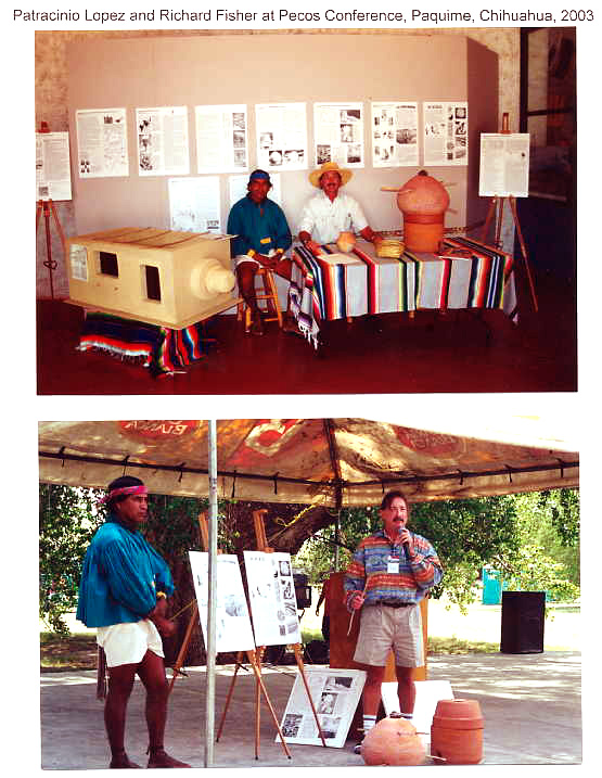
Paquimé: The Anasazi Rosetta Stone
June 2004
with Kate Bauer - Research Associate
Based on new archaeological data and original analysis of published research, made possible by discoveries at the Paquimé Sky Island site, and using a natural and human systems model for interpretation, I present a comprehensive study for an integrated system of food production among the Paquimé, Anasazi, and Hohokam; this includes structures for the institutional production of fertilizer, the means for both short and long distance transport of grain, and long-term surplus corn storage strategies. I propose that these three cultures during their most highly organized stages produced, transported, and stored many tons of surplus food during good agricultural years. I also present an alternative analysis of public architecture at the Sky Island Paquimé culture site, Pueblo Grande and Wupatki, Arizona, and at Chaco Canyon, New Mexico. I propose a new paradigm for the comprehensive reinterpretation of Hohokam “ballcourts” and some Anasazi/Paquime reservoirs as structures to produce fertilize. I propose a new system of ancient agriculture using the extensive Hohokam canal system in the Salt River Valley at the site of modern day Phoenix. I include an analysis of abstract ceramic and architectural design relating to the religious symbolism of agriculture. I also include an analysis of dietary deficiencies as connected to complex human social systems and centralized city-states in the Oasis America environmental bio-zone. Finally, I provide a condensed summary of the major archaeological papers addressing issues of sophisticated agricultural strategies, scale models that can be tested to demonstrate a scientific outcome, a re-analysis of previous theories based on archaeological research conducted since 1995, and gentile Tarahumara ethnographic reports concerning agricultural strategies as validated by basic sciences as applied to agriculture, hydrology, and climate.
 |
||
| Paquime Granary Row |
||
 |
||
| Cliff Palace Mesa Verde Granary Row |
||
 |
||
| Pueblo Bonito Chaco Granary Row |
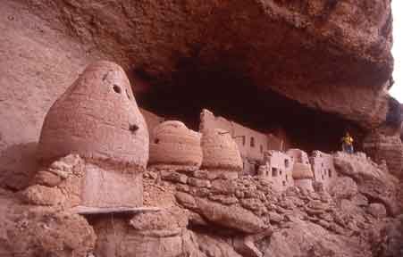
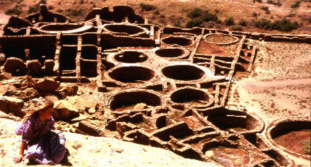
Paquime Granary Row
It was these unique granaries that started the entire project to research and understand complex Paquime/Anasazi/Hohokam agricultural strategies. With the exception of some "base rings" found at several Solado sites, these granaries appeared to be unique throughout the desert canyonlands oasis regions of North America. The Paquime culture area continued to follow Mesoamerican religious concepts until approximately AD1425-1475. Therefore, kivas did not become a part of the religious landscape at Paquime, rather platform mounds appear to be the dominant religious features along with the Paquime House of the Well and the Sky Island "female" cave structure.
To survive in large, complex communities, such as those found throughout Oasis America , particularly at Paquimé, Chaco Canyon , Pueblo Grande, and Casa Grande, advanced agricultural technologies and strategies are essential. To ensure sufficient food supplies, these must include production of fertilizer, reliable long distance transport, and efficient long-term storage of food. I will present compelling historical (Aztec), archaeological, and ethnological (Tarahumara Indian) evidence that these technologies and strategies were practiced by the Paquimé, Anasazi, and Hohokam cultures between about AD 700 and AD 1450/1475. As corn was the basis of life for these cultures, it is not surprising that religious designs and symbolism are found to permeate articles associated with agriculture. Corn alone cannot sustain health, however, and as the ready supply of dietary iron and to a lesser degree animal protein for such large aggregates of people began to disappear, the entire structure broke down, as well. Using this original but well-supported analysis, I am able to present a more complete picture of the rise and fall of Oasis America than has previously been possible.
The foundation for my analysis is a natural and human systems model . This involves applying a global, historical approach to the data being studied, in this case, the Paquimé/Anasazi/Hohokam cultures. As defined by David Keys in Catastrophe (1999:ix), his theory of “evolved determinism” states that forces of nature and “a plethora of consequent ecological, political, epidemiological, economic, religious, demographic, and other mechanisms” interact with each other and ultimately determine the course of human history – outweighing the influence of specific actions or achievements of humans. In this way, irreversible change is effected, such as that experienced by the Oasis America cultures.
Fertilizer and Crop Production
Soil Productivity
The first issue to consider is soil productivity, which is affected by the following three factors:
Fertility of the parent soil type
Orographic lifting
Pest control
In a 1988 soil analysis done by Robert H. Schmidt, Jr., Ph.D., and Rex E. Gerald, Ph.D., they state (1988:165, italics added):
The occurrence and distribution of water-control devices in the northern Sierra Madre Occidental can be explained on the basis of the soil’s parent material and, to a lesser extent, by the seasonal distribution of precipitation . The area at the northern and western extremes of the Sierra Madre are associated with andesite surface rock which weathers more rapidly and produces a more fertile soil than the rhyolite-derived soils found to the east and south. A more even distribution of moisture occurs on the western, or Sonoran, side of the continental divide than that associated with the Chihuahuan Desert regime on the east. Thus, more moisture is available for agriculture during the growing season on the western slope . My investigation indicates that water-control systems were constructed by local groups to increase agricultural production on sloping land and were not part of a massive, but incomplete, project to protect irrigated fields downstream, as contended by Di Peso (1974).
Andesite and rhyolite are both fine-grained volcanic rocks that were formed during the Tertiary Period; andesite is richer in iron and magnesium than rhyolite, however, and produces greater soil fertility (Schmidt and Gerald 1988:170). According to Schmidt’s theory, which he proposed at the Department of Geological Sciences, UTEP, the extensive agricultural terraces in the northern Sierra Madre were based on soil fertility, which comes from the parent geological strata and from the dramatic orographic lifting caused by the canyons of the western Sierra Madre . As related specifically to geological parent soil resources, this terracing phenomenon is also apparent in the Gila and, to a lesser degree, at Mesa Verde.
Given that the terracing system is the largest known Paquimé/Anasazi construction, Schmidt’s theory provides an important and significant foundation for it. (See Figures 1a-1c.) The terracing system represents many hundreds of thousands of man-hours and may be equal in terms of necessary labor to all of the other known Anasazi architectural constructions combined. It certainly indicates a considerably greater investment in labor than all of the buildings at Chaco Canyon . Using a natural systems model , it is also clear that the widespread use of agricultural terraces represents one of the most important Paquimé/Anasazi cultural contributions and highlights the central role of agriculture throughout Oasis America .
As pointed out by Schmidt and Gerald (1988:168), virtually all water control features, i.e., terraces, found in the northern Sierra Madre Occidental occur below 2,000 m, where there are at least 160 frost-free days. The importance of elevation is also shown at Chaco , where the location of the outliers clearly indicates that elevation played a more important role than soil type in determining where outliers and their associated agricultural fields were situated. At optimal elevation, the beneficial effects of increased rainfall due to orographic lifting were felt; in addition to more rain, there were also at least 160 frost-free days, along with hard winter freezing and heavy snowfall. These conditions provided natural pest control, primarily, in the case of corn, of root cutworm.
Fertilizer
In addition to inherent soil productivity, rainfall from orographic lifting, and elevation-enhanced pest control, the issue of fertilizer must be addressed. Was it produced, and if so, how? How was it used?
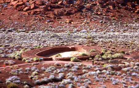
Wupatki Female Fertile Rain Magnet
This Sweetwater Mulching Reservoir is the bridge between Anasazi and Hohokam culture groups. The double masonry walls around this architectural feature share many characteristics of the Mummy Lake reservoir at Mesa Verde in that high sugar content corn could have been grown between the supporting walls. The shape is reminiscent of the previously misidentified Hohokam "ballcourts." Wupatki has many pre-Anasazi reformation AD1275 characteristics while the archaeological evidence indicates a pilgrimage and trade zone for both Anasazi and Hohokam cultural groups. Wupatki also has a strong Mesoamerican connection as the Sinagua area had 53 Scarlet Macaws uncovered and Wupatki had more than any other site north of Paquime.
The geographical placement and shape of this Wupatki feature is the "Rosetta Stone" for unraveling the Hohokam "ballcourt" mystery as well as a major piece in clarifying the agricultural, architectural, and cultural puzzle of Oasis America. This anthropomorphically correct shape is the receptacle of fertile male sky god liquid or monsoon thunderstorms which have a measurable quantity of "fixed nitrogen" and is specifically beneficial for the growing of corn during the C4 period of explosive growth.
Across pre-Columbian North America , water features have been found that have perplexed archaeologists for years. From Mummy Lake , Colorado , to the (“ballcourts”) of Wupatki and Pueblo Grande , Arizona , and to the extensive lakes and wells of Paquimé, these structures have been an ongoing mystery. Thousands of artificially constructed water and organic debris catchment basins dot the landscape from the Hohokam and Anasazi in the north to the Aztec and Maya in the south. Our unique proposal is that the Paquimé/Anasazi cultures and indeed all major complex Native American cultural systems from Mesa Verde to the Yucatan built public architecture that was used for the institutionalized production of fertile water (gray water) and mulching material used on the cornfields associated with these artificially constructed basins. I propose that the Hohokam “ballcourts” are in fact catchment basins for rainfall. In other words, these water features represent a well-planned and carefully constructed system of “sweetwater mulching swamps” whose purpose was the production of fertile sediment.
I also propose that the sweetwater mulching swamps were specifically designed to catch monsoon rainfall that contains “fixed nitrogen” that is useable by plants. This specific type of rainfall is caused by the electrical discharges associated with these seasonal storms.
The scientifically incorrect term for this “fertile rainfall” used by gardeners and horticulturists is “ionized rain.” Rain falling during a thunderstorm will contain a greater concentration of dissolved inorganic nitrogen compounds (“fixed” nitrogen) than rain falling when there has been no lightning. All plants require inorganic nitrogen compounds for growth; atmospheric nitrogen (and organic nitrogen compounds) cannot be used directly by the plant. So, rain falling during a thunderstorm will “fertilize” the soil better than rain falling when there has been no lightning.
Ethnographic reports by the gentile Tarahumara indicate that rainfall accompanied by lightning comes from the “male” Tata Dios and everyone knows, so “it goes without saying” that it is more fertile than normal rainfall. Gentile Tarahumaras report that the male (½) sky sends down his (semen) during intercourse with the female (½) earth. These Tarahumara relate that they are the “children” of god and see the relationship between the earth and sky including the act of intercourse in a very anthropomorphic way. There are not two gods, but rather a father and a mother which are unified as one god. They do recognize that each half of the whole has unique characteristics. Life can only originate from the whole. Everything in the universe is explained as a whole with various characteristics as a part of the male/female, or in their view, the female/male relationship. Once this very simple concept is understood, much of the religious, environmental, agricultural, architectural, and artistic designs can at least in part be deciphered and interpreted by modern scientists. (The gentile Tarahumara are a group of extremely isolated indigenous non-Christian people who have never had a government school in their village region. This location is in west central Chihuahua on a roadless spur of the Sierra Madre Occidental . They take pride in having never been Christianized and are extremely independent and relatively hostile to the very few foreigners that venture into their extremely rugged canyon homeland. They are called “gentile” by their surrounding Christian Tarahumara and Mestizo neighbors. I am one of perhaps three college educated persons that has been able to establish a long term friendly communication with these folk over the past twenty years.)
At least nine percent of all naturally occurring “fixed nitrogen” comes from thunderstorms. Based on this scientifically correct ethnographic report, I will use the term “fertile rainfall” to refer to this critically important phenomenon.
In addition to fertile rainfall, the other two types of naturally occurring inorganic nitrogen compounds found in nature are caused by cyanobacteria (and other bacteria) as it breaks down organic material. The third type of biologically useful nitrogen is supplied by legumes such as mesquite. I propose for further study that the Hohokam “ballcourts” used compost material including human and animal waste, as well as mesquite bean pods, pollen, flower and leaf materials to be broken down by bacteria in the mulching swamps to produce a very potent liquid mixture of fertilizer. The unexcavated half of the large Snaketown “ballcourt” and other similar depressions would provide a perfect test area for this proposal.
Organic material, from plants, animals, and humans, and charcoal were then added to the fertile rainfall, which, in the heat of the summer sun, produced an organic gray water solution used to fertilize the corn at the specific C4 genetic characteristic inherent in the corn growth cycle. As a result of fertilization, the corn had increased sugar content; this specialized corn was used in religious ceremonies.
It is possible to determine whether corn has been fertilized by the size of the cob and the corn kernels. Such studies have been done in Mesoamerica but not yet in relation to Oasis America . I believe this represents an important direction for future research as well.
My sweetwater mulching swamp proposal has recently received substantial support from a major new archaeological analysis of the ancient site of Mummy Lake , in Mesa Verde National Park . This feature’s use was previously unknown, though it has been surmised that it might have been a dance floor, an extremely large kiva, or even a reservoir for irrigation water. Mummy Lake is a shallow pond, about 100 feet in diameter, with an “early intake system.” What is unique is that two, possibly three, stone walls surround the pond area. Recent research by Kenneth Wright, P.E., a specialist in paleohydrology, demonstrates that this was unquestionably a reservoir. Wright’s research team found deposited sediment between the two walls, which they assumed was simply waste or excess material taken out of the reservoir. They also found that this sediment was layered with large quantities of corn pollen. Corn pollen does not blow very far and tends to drop directly to the ground. The unmortared rock walls that defined the edge of the pond would have helped to sub-irrigate the cornfield that surrounded the water; it is easy to imagine a lush, green 20-foot wide garden with corn, beans, and squash surrounding this small pond. I propose that what has been discovered is a sweetwater mulching swamp that was a major designed construction by the Anasazi. As with the other cases in my study of complex Paquimé/Anasazi/Hohokam agricultural strategies, such an interpretation in my view is not only possible, but probable.
In most known cases, a large number of potsherds associated with water transport ceramics have been found near Paquimé/Anasazi water features. These specific utensils were items of high religious significance and were used to apply the fertile water to the fields. In the Mummy Lake excavations, of more than 2,500 sherds collected, 86 percent are jar forms and 87 percent are white wares (Wilshusen, Churchill, and Potter 1997:674). In addition to jar forms, the potsherds also come from ladles (1.1 percent) and bowls (12.4 percent) (Wright 2000:43); this is similar to the potsherd distribution found by Smith and Zubrow in 1967 at Morefield Reservoir. The type and distribution of potsherd shapes imply that Mummy Lake was a specialized use structure (Wright 2000). At the Woods Canyon Reservoir, too, the very high percentage of white ware jars and low percentage of gray ware utility ware sherds strongly indicate a special use site rather than a habitation site (Wilshusen, Churchill, and Potter 1997).
The primary background data for my proposal regarding public architecture used to produce fertile water came from Richard H. Wilshusen, Ph.D., Wright Paleohydrological Institute, Vernon Scarborough, Ph.D., and Charles Di Peso, Ph.D.
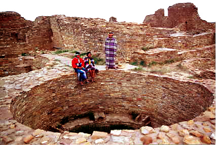
At Chaco Canyon , evidence is found in the abundance of cattails and the construction of “rincons” in the archaeological record. Along with the great number of cylindrical ceramics that may have been used to transport fertile water to the grid gardens and fields, these rincons at Chaco Canyon are a prime candidate for the sweetwater mulching swamp concept. On the Pajarito Plateau there are numerous large ‘U’ shaped reservoirs or water catchments that remain unexplained. Evidence provided by C.D. Allen of the US Geological Survey also suggests that these late phase classic pueblo features may have been enhanced by water collection from rooftops and plazas. As indicated by some of the Mayan reservoirs, water catchments from plazas and living areas such as rooftops were very likely gray water resources and not used for drinking water. At Paquimé, there are numerous probable gray water reservoirs and wells. Charles Di Peso provides evidence that the House of the Well had two full bison and numerous other animals interned in the cistern in the center of town. From the Di Peso Paquimé map numerous reservoirs are constructed adjacent to mounds. Other identified cisterns, reservoirs, or ponds are the termini of drains that pass through residential areas as well as locations where animal waste products might be found, such as House of the Macaws. It is clear that the water system at Paquimé passes through virtually all areas of the town. Many of these have been identified as sewage drains. These drains all end in some type of identified water retention basin. It appears that most if not all of these basins, reservoirs, wells, ponds, and cisterns probably collected gray water for production of fertilizer. For further research some of these wells were community resource locations, and others may be associated with family or clan ownership.
From Paul Fish, Ph.D., I received evidence that modern Pima as well as other cultural groups use the detritus, along with legumes, to enhance soil fertility. Using my natural and human systems model , my 2002 interpretation of sweetwater mulching swamps represents the first known proposal that detritus was used in an organized way by the Paquimé/Anasazi/Hohokam cultures.
Taking my interpretation one step further, I propose that all Hohokam/Paquimé “ballcourts” should now be re-evaluated as potential sweetwater mulching swamps (see Figure 2). Many of the smaller courts appear in clusters and in association with agricultural activities, presenting a high probability that the Hohokam were using the same type of fertilizer-producing water features as the Anasazi and Paquimé. All courts that were not constructed to naturally drain after rainstorms and from which organic sediment is being removed during periodic cleaning were most likely constructed as specialized agricultural enhancements.
In addition, I propose that, regardless of size, all ballcourts that collect rainwater during the monsoon season should be re-evaluated in light of the mulching swamp concept. Hohokam and some Paquimé ballcourts have topographically depressed centers, raised oval sides, and floors that were sealed with caliche or other material so they would hold water.
The shape of the Hohokam “ballcourt” has long mystified archaeologists, as it does not conform to any of the other known ballcourt designs from pre-Columbian North America . Again using the gentile Tarahumara interpretation of female/male religious system, the “ballcourts” when viewed from the sky are the universal symbol of female fertility. This shape might be interpreted as an architectural design by the Hohokam to attract the fertile rain to the specifically appropriate shape constructed in the mother earth. This may also explain why some of the more dramatic “ballcourts” are associated with platform mounds. (The early Spanish went to great lengths to suppress this universal female religious design pattern. Natural systems and the female aspect of the universal paradigm is not a part of the European belief system. This religious symbol reemerged quite dramatically in the well known Virgin of Guadalupe, which contains some of the readily-identifiable elements including the aura, labia and is included with the Spanish bull horns. While indigenous people see the complete shape of the female goddess with the Native American (correct) skin color, it is accepted as the representation of the “virgin” which is a Roman Catholic Christian cameo.) I propose for further study that these two elements be reevaluated as a “wholistic” ceremonial religious complex.
Also, “macaw stones” – the uniquely shaped doors to the macaw pens found at Paquimé – are associated with the numerous regional Paquimé ballcourts. Yet, Scarlet Macaws are specifically associated with water control. Why, then, would macaw stones be found in ballcourts, a highly unlikely location for water control apparatus? Macaw stones were fashioned with a great deal of attention to detail and significant investment in labor, and it is clear from their design that these doors could also be used as intake or outlet valves for water features. I propose, therefore, that many of the so-called Paquimé ballcourts are actually water retention features related to the production of fertile (gray) water. Further, if some Paquimé ballcourts were in fact water features, then it is plausible that some features in the Hohokam area currently identified as ballcourts could also be water features. This original analysis provides a viable alternative to the current practice of identifying any feature with an elongated or oval shape as a ballcourt.
In summary, the general characteristics of sweetwater mulching swamps include the following:
Topographically centralized depressions behind one or two oval or circular dams of masonry or earth
By design and function collect rainwater from a relatively limited area or catchment
Hold water for a short period of time, especially as associated with monsoon weather patterns
Stratigraphically demonstrate a distinct layer of organic material above a floor sealed with plaster, adobe mud, or caliche
Often associated with sherds of water transport vessels of high quality and design features
Located near towns (Anasazi/Paquimé) or habitations with a closer water supply of higher quality or quantity
Also found in predominantly agricultural resource areas not closely or directly associated with known towns or habitations (Paquimé)
It has long been a mystery why the Oasis America cultures chose sites that were not associated with the major sweetwater streams and rivers of the region. I propose that it was not specifically water they were interested in exploiting, but rather a system of fertility that is not clearly understood currently. The gentile Tarahumara report that it is fertility and rainfall taken together that is the focus for their agriculture. They report “it goes without saying” that rainfall is of little value without fertility and that fertility is of little value without rainfall. In their religious view only the two halves constitute the whole.
One of the big questions in archaeology is: Why did the Hohokam build the largest irrigation canal system in the western hemisphere? I propose a completely new paradigm for the comprehensive reinterpretation of this dramatic human effort. Using the “natural and human systems” interpretation, I propose that the Hohokam canal system was constructed to irrigate a vast bosque of mesquite trees. These trees provided in equal parts the essentials of food, fuel wood and charcoal, building materials and soil fertility, as mesquite is a nitrogen-fixing tree or legume. It can also be speculated that this forest actually created a microclimate of moderate temperatures as well as increased humidity. John P. Andrews and Todd W. Bostwick speculate on the disappearance of the Hohokam in their book, Desert Farmers at the River’s Edge. Here they make reference to the problem of salinity, yet dismiss it, saying, “The fact that the Hohokam practiced irrigation agriculture successfully for more than 1,000 years indicates that they had addressed this problem [of salinity].
In a comprehensive survey of experts on western rivers, I have noted that the Salt River salinity historically remained somewhat consistent as the salts come from specific geological sites or salt beds that have not changed to any dramatic degree in the past 2,000 years. I also found that the Salt River (1,100 mg/L) is almost five times as salty as the Rio Grande near San Ildefonso (196 mg/L), the Chama River at Chamita (187 mg/L), and twice as salty as the Colorado River at Lees Ferry (538 mg/L). It has been noted for years and verified for this report in the references that beans are very salt sensitive and that corn is moderately salt sensitive, scientifically contraindicating the extremely saline Salt River as the major source of water for these crops. I propose for further study that a new direction of research for the purpose of the extensive Hohokam canal system is this mesquite bosque proposed.
![]()
Long Distance, Heavy Weight
Grain transport throughout the Paquimé/Anasazi/Mesoamerican system from the growing fields to the storage facilities ranged from at least 60-90 miles to the occasional much longer distance; weights carried ranged from 100-150 pounds (Malville 2000). Numerous dramatic historical accounts of efficient foot transport of commercial food and utilitarian goods have been documented worldwide. The table below, assembled in July 2003 by Mary Ellen Ergle, Park Ranger, shows weights carried by Tlingit packers over the Chilkoot Trail in the late 1800s.
Even today, this mode of transport is widely used in Nepal and other mountainous and roadless areas of Central Asia . In a 1995-1996 study conducted on three major trade routes in eastern Nepal, porters were found to carry loads ranging from 59 kg (about 130 pounds) to 79 kg (about 173 pounds), with some exceeding 90 kg (198 pounds) (Malville 2000). Male porters as young as 10 were carrying loads that averaged 74 pounds. One trade route, from Jiri (elev. 1990 m) to Namche Bazaar (elev. 3440 m) has a cumulative elevation gain of about 6500 m over its length of 95 km (about 152 miles). While Nepal is more mountainous than Oasis America , elevations are similar (about 1200-3500 m) (Malville 2000).
Based on my natural and human systems model , it is clear that the Paquimé/Anasazi/Hohokam were eminently capable of carrying similar weight loads over similar distances. In fact, the Lightfoot efficiency transport model of 50 pounds and 30 miles is within the current Tarahumara range of daily economic and food redistribution activity .
Documented heavy weight loads that were carried short distances in Oasis America include logs and round stones found at Chaco . Long distance carrying involved the trade in Scarlet Macaws (discussed later in this paper) and is verified by the two tons of shell from Banderas Bay found at Paquimé.
Transhumance: Across Ground Daily, Weekly, Seasonally
Recent research by Michael E. Whalen and Paul E. Minnis (2001) on the Paquimé “zone” pattern of settlement provides the details of a “transhumance” settlement strategy, although they do not interpret the data in this manner. The transhumance interpretation has not been widely accepted as daily, weekly, or even seasonal agricultural strategy; however, Whalen and Minnis have gathered data that strongly indicates a Paquimé pattern of transhumance distance zones. In my analysis, the inhabitants of Paquimé’s Casa Grande pueblo had one or more homes of varying sophistication, in addition to their main residence in town; these additional homes were within the central zone and perhaps also in the outer zones. Using my natural and human systems model , my theory is further supported by the transhumance practices of today’s Tarahumara Indians.
Transhumance/seasonal migration is a concept originating from French and Latin roots (trans=across, humus=ground) and means, literally, “across ground.” While the term is applied specifically to Central Eurasian herding cultures, it also can be applied to Oasis America cultures as they moved across the landscape planting corn throughout a regional area. As there is a very contentious debate about the semantics of this word, I would recommend that two options be considered. The first option is to have listed in the dictionary (1) the European definition which refers to the Eurasian practice of following herds from winter to summer pastures and (2) the new world practice of moving seasonally from two designated homes for the purpose of planting crops. The second option would be to use the very simple and direct terminology applied by the gentile Tarahumara. The term that is used is “cambio nivel” or translated to English “change of level.” (Currently, I do not know the Tarahumara Uto-Aztecan word root for this common practice and as such it remains a topic for future research.)
Vernon Scarborough, Ph.D., and numerous other archaeologists have published findings that pueblos in Oasis America planted widely across their territory and that central pueblos (such as Chaco Canyon ) had low population densities during the growing season. Transhumance is also accepted by Grand Canyon and Glenn Canyon archaeologists, while the concept of “task groups” is widely accepted for the Mesa Verde/Yellow Jacket/Crow Canyon region.
In the Grand Canyon , the relationship between the plateau and the canyon has been studied in depth by Douglas W. Schwartz, Jane Kepp, and Richard C. Chapman (The Walhalla Plateau 1969). They state that above average rainfall beginning about AD 1040 must have made the Walhalla Glades (canyon rim habitations) eminently suitable for farming by AD 1050. “In response, small field houses associated with artificial terraces, garden plots, and check dams began to appear in every area in the Glades” (1969:125). Archaeological evidence, such as a scarcity of hearths, indicates the Walhalla Glades were occupied only in the summer and early fall, while excavated sites in the canyon uncovered large quantities of artifacts, suggesting that these sites were occupied fairly continuously. “They could easily have been the permanent homes of the farmers who cultivated crops during the summer in the Walhalla Glades” (1969:130). Also, no kivas have been found in Walhalla Glades while four have been excavated in Grand Canyon , again easily explained by short-term habitation on the plateau and more permanent habitation in the canyon. Looking at pottery remains, the plateau and the canyon were “obviously part of a single ceramic tradition because they produced exactly the same wares and types” (1969:131).
In Glen Canyon , an excellent case for seasonal migration is made by Paul V. Long (Archaeological Excavations in Lower Glen Canyon, Utah, 1959-1960 1967). He proposes that prehistoric people, living permanently on the highlands to the south of Glen Canyon , particularly Cummings Mesa, utilized Lower Glen Canyon on a seasonal basis for farming and gathering raw materials for tool manufacture. Citing Lipe (1960:43-67), Long says there is little evidence of permanent occupation in Lower Glen Canyon except at Talus Ruin. Also, an extensive trail system links river sites on the left bank with known pueblos on Cummings Mesa; during the ceremonial cycle, people farming the river terraces could have used these trails to return easily to their home pueblos for religious rites. In all, the bulk of evidence gathered from the 39 excavated sites in Lower Glen Canyon indicates seasonal habitation there. “…for the most part, the sites on the left bank and many on the right bank are primarily seasonal homes of people planting and harvesting crops on the river terraces and bars along the Colorado River in Lower Glen Canyon” (1967:68).
The pattern of burials documented in Glen Canyon , Grand Canyon , Chaco Canyon , and at Mesa Verde provides additional, key support for my Oasis America transhumance/seasonal migration theory. Only four burials have been found in Lower Glen Canyon , while burials in the highlands are relatively numerous (Long 1967); in Grand Canyon , the opposite is true: there is a paucity of burials on Walhalla Plateau and there are many burials in the canyon bottom (Schwartz, Kepp, and Chapman 1969). In both cases, the findings corroborate shorter seasonal habitation where there are few burials and more permanent habitation where most burials are located. At Chaco Canyon , few burials have been found in relation to the number of great houses (Noble 1984), indicating Chaco ’s function as a special use storage, ceremonial, and winter habitation center. At Mesa Verde, too, there are relatively few burials at the site itself, suggesting its use as a seasonal summer residence rather than a permanent habitation. In my analysis, a paucity of burials and short-term seasonal residence clearly go together, as do an abundance of burials and longer-term, primary habitation.
At Chaco , the outliers were well within the documented transhumance range. Based on natural and human systems , the concept of outliers is easily applied to the newly discovered Sky Island Paquimé culture site, as well as to the numerous other Paquimé sites. As these Paquimé sites fall into the same distance range as similar sites at Chaco , they could justifiably be called Paquimé outliers. This analysis reflects similar archaeological theory denoting Chaco and Paquimé as special cultural phenomenon that might be considered an extended “city-state” political system. Such special status aspects of Chaco and Paquimé are held by many archaeologists, most notably Charles Di Peso, Ph.D., and Steve Lekson, Ph.D.
Perhaps to facilitate transhumance movement, Chaco architectural design provides for “exterior doors on the back sides of great houses which indicate that these rooms could have been road related” (Strutin, 1994:45, italics added). “Perhaps,” her hypothesis continues, these rooms “were meant for storing goods that came in from outlying communities” (Strutin 1994:45). Our alternative theory proposes that these rooms could also be interpreted as providing shelter for agricultural social elements during seasonal visits to the Canyon , or, in other words, a form of transhumance housing support structure. In a worldwide context, historical as well as current, rooms fronting on a road usually provide shelter for travelers or visitors, not for goods that are important enough to store. Specifically at Chaco, agricultural produce and other valuables that had perhaps been carried great distances would be stored in interior spaces, where security was assured by the exterior three to four story high masonry stone walls, while accommodations for people in transit but not part of the extended family would be assured through the basic pre-planned architectural design.
Transhumance agriculture is strongly supported by the large, extensive granaries found at sites such as Pueblo Bonito and the Sky Island culture site. In the Paquimé culture region, corn was widely grown throughout the area, dried, and transported to Paquimé itself, approximately 75 miles from the Sky Island site.
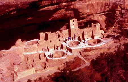
Pueblo Bonito Chaco Granary Row
In expanding on what is known about the Paquime granary system through in-depth review of scientific and archaeological evidence, I am proposing that the key hole granaries of Pueblo Bonito in Chaco Canyon, Cliff Palace at Mesa Verde, and many other areas were in fact granaries prior to approximately AD1275. During this time period the religious basis for the desert canyonlands changed as the Katsina religious concepts became the dominant religion. I am proposing based on the research of Robert M. Adams that this bank of Pueblo Bonito keyhole kivas are actually functional smoker granaries. It is proposed that after the 50 year drought beginning in AD1130 that all the stored corn in these granaries was consumed and residential and other activities occurred in these rooms until the abandonment of Chaco in AD1140-1175. I am proposing that religious activities at Pueblo Bonito were conducted on the platform mounds in front of this structure. I am proposing for further study that all kiva chambers prior to AD1275 were used as functional facilities for food storage, the preparation of penole and/or teswino corn beer. As these food preparation events were highly significant religious feasting ceremonies, these round rooms later became the kiva religious chambers as might be expected.
Today many archaeologists may have perhaps forgotten the "Katsina reformation" in AD1275 when interpreting features in Chaco, Aztec, and Mesa Verde among others which predate this very important shift in Anasazi religion, trade, and politics. Many of the Chacoan features are interpreted using modern Hopi ceremonial traditions which reflect an indigenous movement against the Mesoamerican traders which is thought to have originated along the upper Little Colorado River during the 13th century.
I am reinterpreting Chacoan architecture from perhaps what might be the original utilitarian purposes
Concisely, it is also significant to note that in our timeline date of AD1275 the Katsina religious followers ejected the Mesoamerican diety cult/traders. From AD1200-1275 the Macaw traders were prohibited from entering the Anasazi area. In AD1280 the Kayenta Anasazi moved into the Point of Pines. In AD1250 Paquime was founded. The Kayenta Anasazi were burned out of the Point of Pines and moved south to participate in the San Pedro River, Arizona culture areas. Many archaeologists believe that the Mesa Verde/Aztec/Chaco Canyon Anasazi moved south to join Paquime in AD1270-1290.
Cliff Palace Mesa Verde Granary Row
The design of Chaco Canyon keyhole kivas continues from AD1150 to AD1270 at Mesa Verde and many other sites. I have done extensive testing on the keyhole kiva design and have found that if the chamber is closed it becomes an extreme hazard or death trap for carbon monoxide poisoning if there is a fire or coals inside. This would indicate an affective strategy for pest control during corn storage and would contra-indicate human usage under these specific conditions. As in the case of Chaco/Mesa Verde keyhole kivas the grain would have been completely consumed during drought conditions prior to abandonment of the sites. Even if the site was abandoned for reasons other than drought, it is very likely that all edible materials would have been consumed or moved. It can also be proposed that clan related farmers moved in to the empty chambers that were no longer serving their primary intended function as the outlying areas became more dangerous and indefensible during times of well documented strife and warfare. Archaeologists generally agree that there was a reduction of population to the main centers during times of drought and subsequent social strife. It would follow that chambers used for storing corn in times of plenty and social harmony would be converted to living quarters during times of food shortages and consequent social chaos apparent in the archaeological record. Chaco and Mesa Verde were abandoned pre-Katsina cult which is approximately AD1275. I am proposing that after that time these smoker granaries were very logically converted into the religious kiva chambers that are understood today. I propose that the religious system prior to AD1275 reflected much more Mesoamerican characteristics and was very different than the Hopi and Pueblo Katsina religious system of the modern era. Paquime was the exception until AD1425-AD1575 when it too was attacked and abandoned.
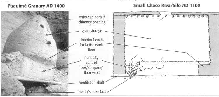
Paquime Granary AD 1400 |
Small Chaco Kiva/Silo AD 1100 |
The gentile Tarahumara report another most critical agricultural reason for the transhumance or “cambio nivel” lifestyle. After fertility and rainfall, the third most important consideration for the successful growing of corn is the control of root cutworm. These Tarahumaras report that root cutworm can completely wipe out the productivity of a good field after several years’ usage. They say that the closer to the frost line, the better the field, as hard freezes and heavy snow during the winter months are the “natural systems” control for these pests. The Tarahumaras can report what we know as the concept of “global warming” as fields that were in past years considered highly valuable due to their high elevation have been rendered useless by the failure of cold winters to kill these grubs. Along with this it can also be noted that higher elevations at the frost line often receive more rainfall through orographic lifting as well as more fertile rainfall during the summer monsoon season. The soil also has a higher humidity content in the spring as the winter snows melt more slowly into the soil and there is less evaporation during the late spring months due to more moderate temperatures. I recommend these four elements for future studies at Mesa Verde as well as at Chaco Canyon , among others.
At Chaco , the corn was grown 10-90 miles away and then transported for storage to central Chaco Canyon villages such as Pueblo Bonito. In dramatic new research published by CNN, Linda Cordell, after more than a decade of intense and productive research, validated scientifically that corn stored at Pueblo Bonito probably was grown in an area located 80 km to the west at the base of the Chuska Mountains . The youngest maize (found) came from the San Juan or Animas river flood plains 90 km to the north. This demonstrates that maize was transported over considerable distances, a finding fundamental to understanding the organization of pre-Columbian southwestern societies. ( October 28, 2003 ) My theory that transhumance/seasonal migration agricultural strategies were practiced in Paquimé and throughout Oasis America indicates that heavy weight, long distance grain transport had to be effected (as I have shown it was), which in turn requires effective corn storage strategies.
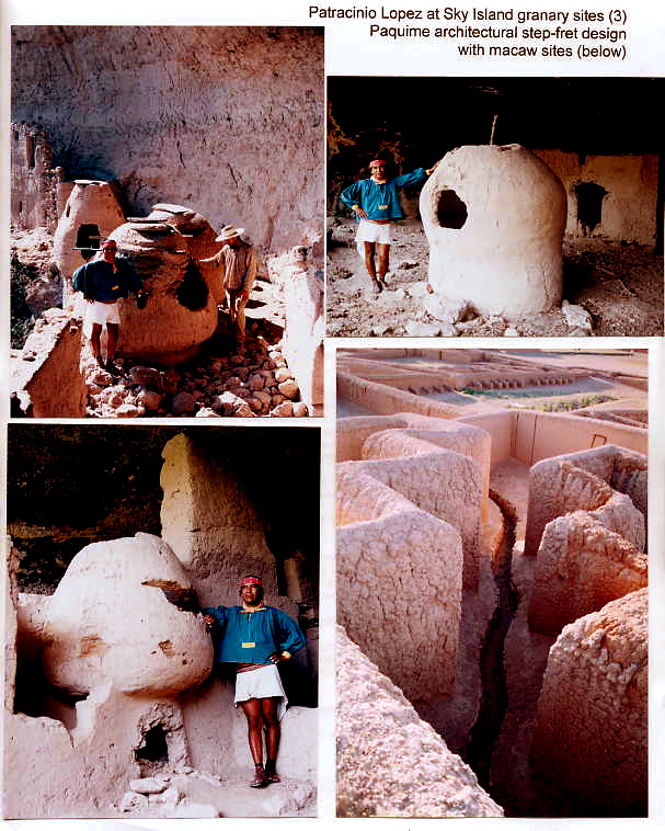
Granaries with unique design features associated with the Paquimé cultural system (AD 1250-1425) have been known to exist in the northern Sierra Madre mountains for over 100 years. In the past decade, granary systems have also been found at several Salado sites, including Schoolhouse Point Mound, and at Punkin Center, where the system is actually named Granary Row Locus 2 (see Figures 3 and 4). Evidence of other granaries exists at Canyon Creek and in the San Pedro Valley , in central and southern Arizona , and in the Mimbres area of southwestern New Mexico (Lindauer 1978:845). All of these appear to be post-Chaco sites. At the recently discovered Sky Island Paquimé culture site, the granaries are both extremely well-preserved and self-evident.
Archaeological debate over the usage of the smaller kivas at Chaco (AD 850-1130) continues, however. Specifically, I am addressing the 10 small, paved key-slot kiva/granaries in Pueblo Bonita’s east wing; the basic question is whether all of the kiva-type rooms were just that, i.e., religious kivas, or were actually, primarily, long-term corn storage granaries. Our natural and human systems model tells us that the Chaco kiva/silos and the Paquimé granary/ollas were specifically designed, technologically advanced structures used primarily for the long-term storage of corn .
Based on my extensive research of Paquimé granaries, I propose that the smaller kivas be re-evaluated as multipurpose structures that, depending on seasonal or periodic needs, were used for three distinct purposes: as smoker granaries/long-term storage facilities, as religious/ceremonial chambers, and, occasionally, as living quarters.
Granary usage explains the hearth and ventilation system that are built into the smaller kivas, features that have confounded archaeologists for years. The ventilation system controlled humidity and provided air passage to the hearth, located below the humidity control box, where a small fire could be used as a secondary method of controlling humidity. Smoke and tannins from the oak wood hearth fire also could have been used as a preservative, protecting the stored grain from mold, mildew, insects, and rodents, while adding flavor, as well.
Corn must be stored at 12 percent or less moisture content or it will mold and become inedible. Silo/kiva “benches” and horizontal wood beam pilasters, like those found in Chaco Canyon kivas and at the Sky Island cultural site, may have supported a latticework floor with an air space beneath to keep the corn dry (Robert M. Adams). Space for horizontal wood beam pilasters is clearly visible on the exteriors of some of the Paquimé granaries.
As shown in Figure 5, the Hohokam had a less well understood structure that had a raised floor, fire pit, and schist stone risers; it is possible that this functioned in the same way as Chaco kiva/silos and Paquimé olla/granaries (Haury 1932).
To provide effective long-term storage, the smoker granaries could be tightly sealed using a thin, round stone and adobe mud. They could still be opened as necessary to control the environment in the storage vault; this could have been accomplished by manipulating the ventilation system during periods of very low ambient humidity using the hearth. Also, as Robert M. Adams, has observed, carbon monoxide from a sealed chamber is a highly effective pesticide that produces no harmful effect on grain used for food. Using an advanced carbon monoxide alarm system, I have performed scientific experiments on scale models of Paquimé/Chaco smoker granaries; they demonstrate clearly that the carbon monoxide produced by one live charcoal briquette exceeds the deadly level by 10 times in less than 60 seconds. This strongly suggests that the Paquimé/Anasazi cultures were well aware of naturally occurring long-term corn strategies – including CO pest control and smoke/tannin preservative qualities – when they designed their granaries. I propose that this highly effective kiva/granary smoker/storage technology helped Oasis America cultures survive periodic severe, prolonged droughts.
Today’s Tarahumara know at all times the ambient humidity in their cornfields, even during the dry season. They know under what soil humidity conditions the seed will sprout without rain and they also know when not to plant the seed at all if soil conditions are too dry to induce sprouting. As virtually no rain falls on the Sierra Tarahumara in the spring, it is only soil humidity that causes the seed to sprout. The difference between adequate humidity for agriculture and too dry is only a few percentage points, yet they know it. They also know at all times the ambient humidity in their storehouses. How they assess these conditions is unknown, but their judgment and accuracy means the difference between starvation and survival. By natural and human systems extrapolation, it is evident that the Paquimé, Anasazi, and Mesoamerican cultures were equally attuned to the requirements of their environment.
The second use of the smaller kivas was as religious and ceremonial chambers. As corn storage and all other aspects of corn agriculture were considered religious practice, the storage facilities would naturally have been the focus of religious activities when empty. When the population of Oasis America began to decline, in AD 1300, there was a shift from a surplus agrarian culture based on corn to the subsistence agricultural-pastoral culture found today. Corn storage facilities were thus left empty and their primary usage shifted to religious and ceremonial activities.
Further supporting my analysis that these kivas were not only, or even primarily, for religious use are the following arguments:
Granaries all over the world are round; most religious structures are not round
Grain is almost always stored in single or double rows of round structures, like those at Pueblo Bonito
Other religious structures – platform mounds – already existed at Pueblo Bonito
These platform mounds have been ignored by most archaeologists, yet evidence of their existence at Pueblo Bonito is clear. The mounds stood 6 feet tall, were surrounded by masonry walls, and were most likely capped with flagstone. They are filled with the remains of hundreds of thousands of water carrying jars. In Mesoamerica , platform mounds were the precursors of pyramids, which, undisputedly, were religious structures. As my analysis shows that the cultures of Mesoamerica and Oasis America were definitely in contact with each other, I propose that the platform mounds at Pueblo Bonito are similar to those found in Hohokam and Paquimé areas and were the primary religious structures at Pueblo Bonito.
Religious Designs and Symbolism
Graphic representations of Paquimé/Anasazi/Hohokam religious beliefs, integrating fertility, male-female balance, weather control, and Scarlet Macaws, are found throughout Oasis America ceramics, rock art, and agricultural design systems. Their presence strongly indicates a connection between these cultures, as well as between Oasis America and Mesoamerica .
 |
|
 |
 |
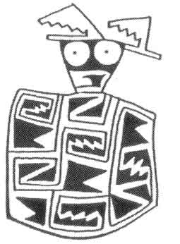
Jornada Magollon Tlaloc AD 750-1000 |
|
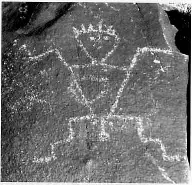
Step-fret and spiral designs, representing the sky, clouds, lightening and other weather phenomenon, are omnipresent in the Anasazi world. They are found on everyday and ceremonial ceramics, in rock art, and in architecture. These designs symbolize fertility and weather control , rather than ancestors or politics (Crown 1994). Their prevalence and uniformity further suggest the ability of the designs to override any economic or political differences that may have existed between cultures at that time (Crown 1994).
Although the Spanish stopped most pottery production with traditional designs in the pueblo region, the step-fret motif has been found in hundreds of thousands – maybe millions – of ceramic pieces, as well as in the architecture itself at Paquimé and perhaps at Zuni. It was reproduced in every known Oasis America culture and in virtually every form of known human communication media for more than 250 years. In my analysis, the step-fret and associated designs were at the foundation of Paquimé/Anasazi/Hohokam culture and religion and had profound, significant meaning. Yet, commonly accepted archaeological explanations for the step-fret design include: It is a simple cloud pattern; the design is so common worldwide that it has no specific meaning; it comes from the basket weave designs of 400 years earlier.
Using my human systems model , I instead looked to today’s gentile Tarahumara for the specific meaning of step-fret and spiral designs. In the Tarahumara belief system, the universe is made up of two essential components, male and female, which fit together in an exactly matching cosmic unity . Humans are created in the image of god and everything in the universe reflects traits of the male-female components that together make up the whole. The designs, therefore, represent the basic male-female relationship, similar to the yin/yang symbolism of Oriental religions. Tarahumaras believe that god awakens in the spring and if the Tarahumaras (god’s children) are dancing harmoniously, then god will make love to his wife and the fluid will fall to earth as rain, enabling the corn to grow. If god’s children are arguing, then there will be no rain and therefore no corn. The Tarahumaras experience these beliefs in a very straightforward, personal way; their ceramics and artwork show versions of the cloud patterns seen in Anasazi design.
Scarlet Macaws and the Monsoon Meridian
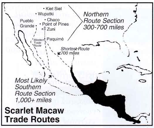
The Chaco Meridian is interpreted by Steve Lekson, Ph.D., as a sacred or religious north-south line connecting Aztec, Chaco and Paquimé cultures. I propose that the route also reflects specific observable climatic phenomena , namely early and late monsoon activity along a line roughly following the continental divide. Using this “natural system” I propose that the numerous major large Anasazi/Paquimé towns arranged roughly along this line are situated to specifically capitalize on the “fixed nitrogen” or fertile rainfall along the continental divide as an agricultural strategy. This adds an environmental element to the religious Aztec/Chaco/Paquimé alignment. I have named this route the Monsoon Meridian and propose further that it constitutes at least part of the trade route followed in the Scarlet Macaw trade.
An abundance of evidence upholds the trade in Scarlet Macaws. Originating in the humid tropical lowlands of southern Mexico , the macaws were transported a minimum of 700 miles up to a total of 1400 miles (Bullock and Cooper 2001? and McKusick 2001). I propose two distinct trips of 300-700 miles each, the first from Mesoamerica to Paquimé, Mimbres Valley or perhaps Chaco , and the second from Mimbres/Paquimé to the northernmost Anasazi/Hohokam regions of Kiet Siel and Wupatki. The trade took place over a 700-year period and provides irrefutable evidence that Oasis America cultures were in intimate contact with Mesoamerica during most of this entire time period.
Scarlet Macaws produce vividly colored red, yellow, and blue feathers, which were and still are used in religious costuming and ceremonies. Yet, Scarlet Macaws require intensive care. They hatch in March and must be removed from the nest at seven weeks of age; they then must be carried in baskets, protected from chilling, and fed chewed hominy, often straight from the keeper’s mouth, every few hours, day and night. They thus become human-imprinted birds, making it difficult to breed adults; it is easier to capture hatchlings.
Given the care requirements, the continual need to capture new birds, and the distance they had to be transported, Scarlet Macaws were perhaps the single most “expensive” acquisition made by Oasis America cultures. The trade continued, however. Of 504 macaws recovered from Paquimé, only 96 were the locally available Military Macaws. By the late 900s, the Scarlet Macaw trade route ran through the Mimbres River Valley to Chaco ’s sphere of influence. Mimbres pottery motifs and the age of skeletal remains suggest that juvenile macaws were brought to the Mimbres sites, raised there for almost a year, and then traded north in time for the spring equinox religious ceremonies on March 21-22. From AD 1150 to about AD 1200, the trade in Scarlet Macaws branched west to the Sinagua area; more Scarlet Macaws (53) were recovered at Wupatki than at any other site north of Mexico . The Scarlet Macaw trade became inactive in about AD 1200 and did not start again until about AD 1275, when the Pueblo Katsina Cult arose. By this time, the Mimbres Villages were vacated and Paquimé had been built. Paquimé specialized in raising juvenile Scarlet Macaws to a marketable size for trade. Osteology indicates that in the early 1300s inhabitants of Point of Pines in east central Arizona traded large Indian domestic turkeys with Paquimé in exchange for Scarlet Macaws (McKusick 2001 and personal interviews with her).
In my interpretation, the Scarlet Macaw trade, along with the uniform step-fret and other design motifs in ceramics, rock art, and architecture, are clear indications that religious beliefs and practices were shared throughout Oasis America during its 700 year timeframe, including the 250+ years covering the existence of Mesa Verde in the north to Paquimé in the south.
The design of the structures previously interpreted as ceremonial macaw birthing chambers, with their anthropomorphic male “plugs” that fit into round female macaw stones, brings my analysis back to fertility. Though these enclosures have been called macaw nesting boxes, macaws are not likely to breed or nest under the conditions these boxes present. Our alternative suggestion is that the Scarlet Macaws were seen to exit Mother Earth during major religious ceremonies, such as at the spring equinox, and were then lifted by the priest to greet Father Sky. Further, my proposal is that macaw stones were actually water control devices, used as intake/outlet valves in the architectural structures I suggest are sweetwater mulching swamps, rather than ballcourts. In this context, macaw stones have the religious significance of releasing fertile water, thereby completing the rainwater/fertility cycle for the corn crop. Macaw stones show an isomorphic pattering with ballcourt distribution (Whalen and Minnis 1995). However, the actual layout and design of the sweetwater mulching swamp as related to the macaw stone requires further study for full understanding.
Dietary Deficiencies in Oasis America and the “Lost Anasazi/Paquimé Trade Route”
Cribra orbitalia/porotic hyperostosis is a disabling skeletal disorder caused by iron-deficiency anemia. Evidence of this condition is broadly found in virtually all late date Oasis America mega-sites where human skeletal remains have been analyzed . Severe malnutrition is evident in the remains of adults and children, both male and female. In conjunction with this, there is dramatic evidence in the archaeological record that large mammals, such as deer, antelope, and bighorn sheep, were frequently consumed during the founding phases of virtually all the Paquimé/Anasazi/Hohokam pueblos.
At Paquimé, a high percentage of the bone recovered was from bison. This makes Paquimé unique, as no other site excavated in the region, including those that predate Paquimé, uncovered any substantial amount of bison bone. In addition, the House of the Well in central Paquimé, shows evidence of two full bison, along with numerous ceremonial birds that were sacrificed there.
In the early days of the pueblos’ existence, the supply of protein was sufficient. In the final phases of their existence, pueblo inhabitants were eating rabbits, mice, and rats to satisfy their protein needs. I originally thought that a general decline in agricultural production caused by lack of fertile soil and a buildup of soil salinity led to the cultural collapse of Oasis America . My archaeological research has clearly demonstrated, however, that the Paquimé/Anasazi/Hohokam cultures were using advanced technological systems to produce fertilizer and store corn. They were also transporting the grain over long distances from the growing fields to the silo-granary storage sites. Enough food was not the problem; rather, it was the lack of available dietary iron.
In a 1965 analysis of 18 Pueblo III burials at Mesa Verde, remains dating from AD 1000-1300 were examined; Reed cited arthritis and dental pathologies combined with low life expectancy as indications of a stressed population (Martin, Goodman, Armelagos, and Magennis 1991:7). Chaco Canyon Anasazi suffered from “subsistence stress,” according to Akins (1986), as indicated by growth disruption, high rates of nutritional anemia, and degenerative diseases (Martin et al. 1991:8). Todd Bostwick, Ph.D. reports that there was high mortality among Hohokam females of childbearing age as a result of anemia during the last phase of habitation at Pueblo Grande and other sites.
A common finding in many paleopathological studies is the presence of nutritional anemia. A study by El-Najjar and colleagues (1976) concluded that a dependence on maize in marginal areas, like those found in the Southwest, predisposes individuals, especially children, to health problems (Martin, et al. 1991:10); Martin and colleagues state that Walker then expanded this finding through an extensive review of published literature on anemia for all the major Southwestern sites and concluded:
The remarkable prevalence of osseous lesions indicative of anemia among prehistoric Southwest Indians apparently resulted from the interaction of a complex set of biological and cultural variables relating to nutrition and infectious disease. Lack of iron in the diet, prolonged breast feeding, diarrheal and helminth infections, and living conditions conducive to the spread of disease all appear to have contributed to the prevalence of [anemia] (1985:153).
Reliance on corn as the primary food source actually increases the need for red meat, as maize inhibits iron absorption. El-Najjar and Robertson (1976) indicate that the Anasazi diet of maize is important in interpreting porotic hyperostosis in the skeletal remains of a child from Canyon de Chelly (Martin et al. 1991:163). Analysis of the corn species used today throughout the Southwest shows it is very low in usable iron, and the iron content of a Mexican tortilla is less than 3.2 mg/tortilla (Martin et al. 1991:163). Red meat enhances the absorption of iron and when it is an integral part of the diet, anemia is not a problem.
There is strong evidence throughout the Americas that large mammals become locally extinct in areas of high human density; the archaeological record indicates that this occurs when social conflict reaches a peak over increasingly scarce natural resources. The Oasis America cultures, suffering from severe anemia because of the lack of health-producing protein sources, had the option of adopting Mesoamerican dietary practices. Despite the fact that any population suffering from severe anemia would be at a tremendous disadvantage against healthy neighbors or invaders, there is well-documented evidence of widespread violence and strife at the end of the Oasis America period, as indigenous tribal groups who were against Mesoamerican practices rebelled against those in favor of that solution to their health needs. The trade route from the Paquimé/Anasazi to Mesoamerica , now known as the “lost trade route,” fell into disuse after about AD 1450 precisely because of the warfare and strife over Mesoamerican dietary practices . Carlos Lazcano reports that by the time of Coronado ’s arrival in 1541 all tribes north of Durango and Sinaloa had rejected the Mesoamerican dietary option.
Using Paquimé as my Rosetta Stone and today’s Tarahumara for expanded interpretation, I can now understand much more clearly the rise and fall of the Paquimé/Anasazi/Hohokam Oasis America cultural systems. Using my natural and human system model , it is clear that the Oasis America cultures were participating in a broadly-based system that stretched from Mesoamerica sites in the south to Mesa Verde in the north and included similar religious, agricultural, and architectural practices over a 700 year time period.
Paquimé is able to function as my key to Oasis America cultures for two reasons:
Exceptionally well-preserved late date ruins, especially at the recently discovered Sky Island culture site
Great wealth and power at the height of its existence, as indicated by their material culture which is carefully documented by Charles Di Peso, Ph.D.
A substantial amount of “high status” copper artifacts, brought from western Mexico , have been found on the steps leading to the central Paquimé well (C. Di Peso and C. S. VanPool). I have shown evidence that trade in the expensive Scarlet Macaws from southern Mexico took place in Paquimé; a large supply of corn from the Sierra Madre, 2+ tons of shell from western Mexico, and bison bones, indicating a protein supply from the Plains, have also been found there. Taken together, these findings substantiate Paquimé’s involvement in an extensive trade network.
The special agricultural, architectural, and cultural features for grain production, transport, and storage set the Paquimé/Anasazi/Hohokam cultures apart from preceding, contemporary, and subsequent pueblo groups. These features include the use of agricultural terraces, located to take advantage of favorable parent soil fertility, increased rainfall from orographic lifting, and natural control of root cutworm and other pests through elevation. Also included is the building of public architecture specifically for the production of fertile water. These sweetwater mulching swamps enabled the production of bigger, sweeter corn for religious ceremonies. Based on recent archaeological discoveries at the Sky Island cultural site and my ongoing research on the production of fertilizer in Oasis America , I propose that all Hohokam and 90% of Paquimé “ballcourts” be re-evaluated as potential sweetwater mulching swamps.
In perhaps my most important proposal, I have been able to provide a plausible ethnographic/archeological explanation for the shape of the “ballcourts” as a religious architectural design representing the physical origins of female fertility. This oval shape ‘()’ also functioned as a practical receptacle for fixed nitrogen rainfall and provided a structure for the mulching of waste materials that dramatically increased the measurable efficiency of the available fertilizer resources.
In terms of grain transport, I have shown that both men and women in Oasis America cultural groups, like the Tarahumara, Nepalese, and others today, were eminently capable of carrying loads of 75-150 pounds or more up to 90 miles and more. This is documented in the archaeological record, which indicates that most adults (both male and female) had spinal degeneration from carrying heavy loads (Martin et al. 1991). More recently it has been documented by Linda Cordell, Ph.D. that maize originating from the Chuska Mountains and at a later date the San Juan and Animas river flood plains was transported in the 90 km range to be stored Pueblo Bonito in Chaco Canyon (Benson and Cordell, October 2003). I have also shown that transhumance, or moving across ground to meet daily, weekly, and seasonal needs, was practiced in Oasis America, as it still is today among the Tarahumara and others.
Storage of corn was accomplished in multipurpose kiva/silos. Our extensive research of the Paquimé granaries indicates that these structures were built primarily for the long-term storage of corn. They were also used as smoker granaries and, particularly as the population of Oasis America began to decline after AD 1300, for religious and ceremonial activities. The specific smaller key-slot kivas at Pueblo Bonito should be re-evaluated as corn storage granaries using carbon monoxide to eliminate pest along with humidity control architectural features.
That all of the cultural groups throughout Mesoamerica and Oasis America shared similar religious beliefs and practices is undisputedly shown in the ubiquitous use of the step-fret and spiral designs in ceramics, rock art, and architecture. These designs symbolize fertility, weather control, and the basic male-female balance that is at the foundation of their cosmic view. The extensive trade in Scarlet Macaws further supports the connectedness of the Oasis America cultures, both with each other and with Mesoamerica .
Finally, the widespread evidence of iron-deficient anemia, as shown by the presence of cribra orbitalia/porotic hyperostosis in Oasis America skeletal remains, indicates the simultaneous collapse of the complex, centralized city-states that had characterized Paquimé/Anasazi/Hohokam cultures. It is probable that large population centers reached a “ceiling” of available dietary iron from animal sources. This factor lead to the choice of adopting known Mesoamerican dietary practices or returning to “indigenous origins” population levels. As the supply of adequate protein sources disappeared, the choice to adopt Mesoamerican dietary practices as recently documented archaeologically – and was rejected as a matter of known historical record. Following widespread warfare and strife, those tribal groups that opted to follow Mesoamerican ways were pushed to the south, while those that remained reverted to living in smaller population densities which did not require extensive agricultural enhancements or architecture and that enabled an adequate supply of large mammals to live in the area, thereby providing an easily-accessible protein source.
Using my natural and human systems model for analysis, I am thus able to provide an integrated and more complete picture of the Oasis America cultures throughout their history than has been possible previously. I am able to offer seven revolutionary new archaeological interpretations for the Paquimé/Anasazi/Hohokam pre-Colombian cultures A.D. 700-1425/1475. These seven proposals are (1) sweetwater mulching architecture, (2) increased load carrying capacity and distance, (3) transhumance agricultural strategy, (4) macaw and shell long distance trade systems, (5) granary kivas for long-term storage of corn, (6) religious interpretation of ceramic art and architectural design, and (7) anemia as the specific cause of the dramatic end of the Paquimé/Anasazi/Hohokam cultural systems. I am able to provide very strong ethnographic, as well as well-documented scientific, historical, and archaeological evidence to support these proposals.
ADDENDUM 1
Pre-Classic Mayan archaeological foundations for these proposals.
Since I completed this paper I have found substantial support that some of these ideas were in circulation since the Mayan pre-Classic period of 600BC-AD150 in the Mirador Basin of northern Guatemala. Professor Richard D. Hansen under the sponsorship of National Geographic and documented on PBS states “the Mirador Basin of the pre-Classic Mayan period had an economic agricultural engine where marsh muck from local swamps was deposited into terraces to produce fertile soil for the growing of corn and other crops. These deposits equaled thousands of tons of organic soil material transported. Some of these terraces were more than 3½ meters (10 feet) deep.” Professor Hansen further stated that these agricultural methods are evident throughout the Mayan era into the Aztec Chinampa swamp dredging agricultural system.
This ancient knowledge would be the basis for our Paquimé/Anasazi/Hohokam “natural systems” agricultural methods for producing fertilizer.
In an additional interesting note, Professor Hansen also stated that “at the time of his death Norman Hammond was investigating ‘Chultunes’ which may be bedrock storage chambers for the purposes of preserving ‘smoked’ corn. This might be the basis for the ancient knowledge of the Paquimé granary/Anasazi kiva long term storage technology.
Reference
Hansen, Ricahrd D.
2004. Project Director Miravel Basin Project and President of Foundation for Anthropological Research and EnvironmentalStudies, Rupert, Idaho. Agricultural Foundation s of Pre-Classic Mayan Civilizations. Personal Interview with Richard D. Fisher, June 7, 2004.
2002. Climatic and Environmental Variability in the Rise of Maya Civilization: A Preliminary Perspective from Northern Peten. Ancient Mesoamerica , 13 (2002): 273-295. Cambridge University Press, Cambridge, England.
ADDENDUM 2 -
Proposal for investigating the natural and human systems theory as applied to the Chaco culture system.
I recently made a short trip to the Chaco cultural area for the purposes of investigating the possibility of analyzing the many mysterious architectural and other features from the perspective of my proposed theoretical interpretation. I also wanted to interview the primary archaeologist in person and in-depth as to the most current thinking on the Chacoan riddle. What I found is that currently most researchers are trying to interpret the Chaco phenomenon from a Hopi/Pueblo ceremonial perspective. Any unexplained item is tossed into the category of “ceremonial.” In most cases, the “ceremonial” interpretation has very little support or relationship with the archaeological evidence pre-AD1275. Even the road system which should have a practical application is identified as a ceremonial feature. I am proposing that these features be evaluated from a practical usage viewpoint.
My previous research indicates a major break in the Anasazi political, religious, and trade system in AD1275. Current Hopi/Pueblo interpretations do not adequately explain the architecture of the pre-Anasazi reformation period. I came away from Chaco with more questions than I began the research expedition with. I also found a great number of “factoids” that contraindicate some current interpretations and support a “natural and human systems” approach to investigating the puzzle. The following is a summary of some of those factoids.
1. For example, I could find no specific architectural construction such as the Hohokam sweetwater mulching reservoir (ballcourt) at Chaco Canyon. There is good reason to believe that the Chacoans had the same knowledge as the Hohokam and the Paquimé culture groups. They should have some type of feature that indicates the practical use of fixed nitrogen rainfall and other strategies for collecting nitrates and phosphates which are both accomplished through mulching in liquid environments. What I did find, however, a system of architectural rings or circles (10-30 meters across) within sight of giant kivas that do collect rainfall in “basins” (Tom Windes personal interview June 3, 2004). I also found dams on rincons that collect detritus and may have been used as gray water mulching reservoirs.
The Chaco road system may also be reinvestigated as a swale. This structure currently collects detritus and perhaps a modest amount of runoff. Cryptobiotic soil is a blue green algae commonly found throughout the Chacoan system. Some research indicates that during the monsoon season this type of biological material produces four hundred times more nitrate than is found in other types of soils when measured in slickrock runoff. Apparently, pollen analysis was not done when the Chacoan road system was trenched and analyzed (Chris Kincaid, personal interview June 3, 2004 ). I am proposing for further study that the cryptobiotic soil along with the known higher summer rainfall pattern during the Chacoan era was exploited by the Anasazi in swales that had been interpreted as roads. As the Chacoan agricultural system remains a conundrum, I propose that the “road system” just like the Hohokam ballcourt system be investigated for a possible agricultural feature . Both are topographical depressions and as such they collect water. In most cases roads as well as ballcourts are built to drain water quickly away. It follows that if the Chacoans built linear swales that in fact collect water, I propose that collecting water and naturally occurring nitrogen carried by water was their intended use.
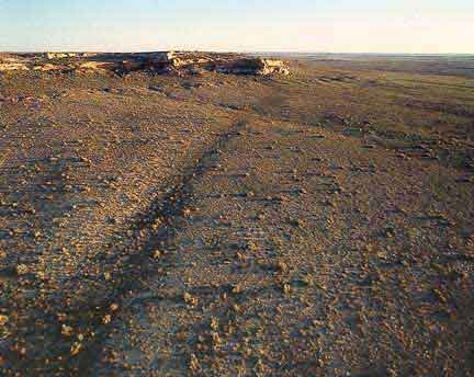
Prehistoric road shows as gentle swale south of Chaco Canyon National Historic Park, New Mexico.
Low aerial view to the north toward Chaco Canyon. Depressions of ancient road beds are quite visible in some areas.
Aerial photograph courtesy of Adriel Heisey © 2004
2. Another example is interpreting giant kivas from a ceremonial only perspective. I propose an in-depth evaluation of giant kivas from a practical and functional perspective. These kivas consistently contain an “oversized” fire structure, two rectangular vault structures, and various numbers of polished sandstone or limestone disks which in some cases are not from the local area and weigh several hundred pounds each (Roger Moore, personal interview May 27/June 4, 2004). One of the various explanations for the floor vaults is sprouting corn or beans. The disks are explained as an integral part of the foundation of support pillars. I don't believe it was necessary to have these disks as a foundation. Rather their shape and size suggests circular grinding stones used in processing grain. I am proposing that during this time period the giant kivas had a utilitarian purpose of producing teswino (corn beer) or penole (parched corn). Three of the four necessary items for producing these two Native American corn products are archaeologically recovered in the giant kivas. The vaults could have been used for sprouting corn, the disk could have been used for producing or grinding the mash, and the fire structure is necessary for either purpose of making teswino or penole. The missing item is the caldron or wok used for boiling or roasting the corn products in large amounts. Certainly, the method for the efficient large scale production of these food products is not known at Chaco , and perhaps some artifacts that may have been used in this process may have been misidentified or misinterpreted.
Temporary Summary of Addendum References May 26- June 4, 2004
Bach, Dan
2004. M.A. Plant Physiology and Owner, Bach’s Cactus Nursery, Tucson , Arizona , Types and Applications of Naturally Occurring Fertilizers. Personal Interview with Richard D. Fisher, June 4, 2004 .
Damp, Jonathon, Ph.D.
2004. Principal Investigator, Zuni Cultural Resource Enterprise , Zuni, New Mexico . Abundant Summer Rainfall AD1050-1150 Chaco Period. Personal Interview with Richard D. Fisher, May 27, 2004.
Heises, Adrial
2004. Aerial Photographer, Tucson , Arizona . Aerial Photography and Observable Aerial Phenomena of the Chacoan Road System. Personal Interview with Richard D. Fisher, June 3, 2004 .
Kincaid, Chris
2004. Bureau of Land Management Coordinator, Glen Canyon National Recreation Area, Page, Arizona . Chaco Road Systems. Personal Interview with Richard D. Fisher, June 3, 2004
Moore, Roger
2004. V. T. Park Archaeologist, Chaco Cultural National Historic Park, Nageezi , New Mexico . Interpretation of Chacoan Architecture/Kivas/Reservoirs/Agricultural Systems. Personal Interview with Richard D. Fisher, May 27, 2004 and June 3, 2004 .
Pawluck, Roman
2004. Program Director, Zuni Conservation Project, Pueblo of Zuni, Zuni, New Mexico, Natural Sources of Fixed Nitrogen, Cryptobiotic Soil and Others. Personal Interview with Richard D. Fisher, May 27, 2004.
Roney, John
2004. Bureau of Land Management, Albuquerque , New Mexico , Chacoan Road System. Personal Interview with Richard D. Fisher, May 27, 2004.
Toll, Wolky, Ph.D.
2004. Office of Archaeological Studies, Museum of New Mexico , Santa Fe , New Mexico . Personal Interview with Richard D. Fisher, May 27, 2004.
Towle, Linda
2004. Chief of Research, Mesa Verde National Park , Mesa Verde , Colorado . Kiva Styles and Reservoirs. Personal Interview with Richard D. Fisher, June 2, 2004
Wheeler, Gerald, Ph.D.
2004. Plant Pathologist and Agronomist, Acre Lab, Tucson , Arizona . Basic Fertilizer Available in Natural Systems. Personal Interview with Richard D. Fisher, June 3, 2004 .
Windes, Thomas C.
2004. Archaeologist, United States National Park Service, Albuquerque , New Mexico . Chaco Circular
Structures and Rainwater Catchments. Personal Interview with Richard D. Fisher, June 1-2, 2004.
References
Adams, Robert M.
A New Paradigm for the Comprehensive Reinterpretation of Southwestern Archaeology: The Kiva as
Corn Bin. Privately distributed draft: Natchez, MS.
Allen, Craig D.
U.S. Geological Survey, Jemez Mountains Field Station. Pajarito Plateau classic pueblo period (A.D.
1400) reservoirs and water retention structures, lightning strike density, production of rainfall in the Jemez and other
mountain ranges in northwestern New Mexico. Personal interview with Richard D. Fisher. April 1, 2004.
Allen, Paul L.
The Mystery Rekindled: An archaeologist’s controversial new theory speculates they were just corn
silos. The Tucson Citizen. November 16, 2002. Tucson, AZ.
Andrews, John P. and Todd W. Bostwick
1997. Desert Farmers at the River’s Edge: The Hohokam and Pueblo Grande. City of Phoenix, Parks,
Recreation and Library Department, Pueblo Grande Museum and Cultural Park: Phoenix, AZ.
Atkins, Nancy J.
Chaco Canyon Mortuary Practices Archaeological Correlates of Complexity. In Ancient Burial
Practices in the American Southwest , edited by Douglas R. Mitchell and Judy L. Brunson-Hadley.
Arizona State Museum Library: Tucson, AZ.
Barey, Patricia
1990. Bandelier National Monument. Southwest Parks and Monuments Association: Tucson, AZ.
Bayman, James M. and Suzanne K. Fish
Reservoirs and Locational Shifts in Sonoran Desert Subsistence.
In Research in Economic Anthropology , Supplement 6, pp. 267-306. JAI Press, Inc.: Greenwich, CT.
Benson, Larry and Linda Cordell
Ancient Maize from Chacoan Great Houses: Where was it grown? US Geologic Survey, PNAS,
October 28, 2003, vol. 100, no. 22, 13111-13115 http://www.pnas.org/cgi/content/abstract/100/22/13111
Berdan, Frances F.
The Aztecs of Central Mexico: An Imperial Society . Case Studies in Cultural Anthropology, pp. 19-23.
CBS College Publishing: New York, NY.
Berton, Pierre
1965. The Klondike Fever: The Life and Death of the Last Great Gold Rush. Alfred A. Knopf: New York,
NY.
1966. Klondike: The Last Great Gold Rush 1896-1899. (revised edition) McClelland and Stewart Ltd.: Toronto.
Bostwick, Todd W.
City Archaeologist, City of Phoenix, AZ. Pueblo Grande Museum. High mortality of Hohokam women
during childbearing years and anemia. Personal Interview with Richard D. Fisher. August 2003.
The Northwestern Ballcourt. In Archaeology of the Pueblo Grande Platform Mound and Surrounding
Features Vol. 2; Features in the Central Precinct of the Pueblo Grande Community, edited by Todd
Bostwick and Christian E. Downum, pp. 131-143. Pueblo Grande Museum Anthropological Papers
No. 1. Pueblo Grande Museum, Parks, Recreation and Library Department: Phoenix, AZ.
Britt, Robert Roy
Lightning Interacts with Space, Electrons Rain Down. December 16, 1999. Space.com http://www.space.com/scienceastronomy/planetearth/space_lightning_991216.html
Bullock, Peter Y.
1991. Macaws at Casas Grandes and in the American Southwest. Manuscript on file,
Office of Archaeological Studies, Museum of New Mexico: Santa Fe, NM.
Bullock, Peter Y. and Alan Cooper
Ancient DNA and Macaw Identification in the American Southwest: A Progress Report.
The Artifact, Volume 40, pp. 1-10. The Society: El Paso, TX.
Bunzel, Ruth L.
1972. The Pueblo Potter: A Study of Creative Imagination in Primitive Art. Dover Press: New York, NY.
Byzant Symbols
2003. www.byzant.com
California Foundation for Agriculture in the Classroom
Plant Nutrients - Nitrogen. Natural Resource Fact Sheet. Composed by the California Foundation for
Agriculture in the Classroom (CFAITC). Sacramento, CA.
http://www.cfaitc.org/Commodity/pdf/nitrogen.pdf
Chandler, Vicky, Ph.D.
Regents’ Professor, Dept. of Plant Science, University of Arizona. Maize Sensitivity to Salinity.
Personal interview with Richard D. Fisher. March 29, 2004.
Cheek, Lawrence W.
A.D. 1250 Ancient Peoples of the Southwest . Arizona Highways Book Division,
Arizona Department of Transportation: Phoenix, AZ.
Chhabra, Ranbir
1996. Soil Salinity and Water Quality. A.A. Balkema: Brookfield, VT.
Clark, Jeffery J. and Jeames M. Vint, Editors
Tonto Creek Archaeological Project Archaeological Investigations Along Tonto Creek, Volume 2: Site
Descriptions for the Punkin Center Section. Anthropological Papers No. 22.
Center for Desert Archaeology: Tucson, AZ.
Cordy, Gail E.
USGS, Tucson Office, Tucson, AZ. Comparative Salinity of Eight Southwestern Rivers. Personal
interview/email exchange with Richard D. Fisher. March 30, 2004.
Crown, Patricia L .
Ceramics & Ideology: Salado Polychrome Pottery . University of New Mexico Press: Albuquerque, NM.
Di Peso, Charles C.
Casas Grandes, A Fallen Trading Center of the Gran Chichimeca , Volume 2.
The Amerind Foundation, Inc.: Dragoon, AZ.
DiPeso, Charles C., John B. Rinaldo and Gloria J. Fenner
Casas Grandes, A Fallen Trading Center of the Gran Chichimeca, Volumes 4, 8.
The Amerind Foundation, Inc.: Dragoon, AZ.
Ergle, Mary Ellen
Tlingit Packers Over the Chilkoot Trail: Rates and Pounds Carried . National Park Service.
Government Printing Office: Washington, DC.
Ferdon, Edwin N., Jr.
The Hohokam “Ball Court:” An Alternate View of its Function. In The Kiva 33(1): 1-12.
Arizona Archaeological and Historical Society, Arizona State Museum: Tucson, AZ.
Fish, Paul R., Peter J. Pilles, Jr. and Suzanne K. Fish
Colonies, Traders and Traits: The Hohokam in the North. In Current Issues in Hohokam Prehistory,
Proceedings of a Symposium, edited by David Doyel and Fred Plog, pp. 151-175.
Anthropological Research Papers No. 23. Arizona State University: Tempe, AZ.
Foster, Michael S. and Shirley Gorenstein, Editors
Greater Mesoamerica: The Archaeology of West and Northwest Mexico.
The University of Utah Press: Salt Lake City, UT.
Frisbie, Theodore R.
The Chaco Phenomenon and Spanish Colonial Missions Commonality through Paucity. In Prehistory
and History in the Southwest, edited by Nancy L. Fox. Papers of the Archaeological Society of New
Mexico 11:73-90. Archaeological Society of New Mexico: Albuquerque, NM.
Funston, Frederick
1896. Over the Chilkoot Pass to the Yukon. Scribners: New York, NY.
Greer, Sheila C.
Skookum Stories on the Chilkoot/Dyea Trail. Carcross-Tagish First Nations: Carcross,
Yukon Territory.
Hansen, Richard D.
2004. XXXXXXXX Univ. XXXX Agricultural Strategies and Methods of the Pre-Classic Maya at Nakbe, Peten, Guatemala.
Personal Interview with Richard D. Fisher, May 18, 2004.
Haury, E.W.
Roosevelt:9:6 A Hohokam Site of the Colonial Period . Medallion Papers No. XI.
The Medallion: Gila Pueblo; Globe, AZ.
Healy, J.
Papers in Ms. Stefansson Collection. Dartmouth College Library: Hanover, NH. Photocopy on file,
Yukon National Historical Sites; Whitehorse, Yukon Territory.
Imster, Eleanor
Earth & Sky Radio Series Interview, Nitrogen Fertilizer. January 29, 2001.
Byrd & Block Communications Inc. http://www.earthsky.com/shows/shows.php?t=20010129
Johnson, George
1995. Social Strife May Have Exiled Ancient Indians. The New York Times. August, 20, 1996. New York, NY.
Keys, David
1998. Catastrophe: An Investigation into the Origins of the Modern World. Ballentine Books: New York, NY.
KIDDE Safety
1998. Nighthawk Carbon Monoxide Alarm User’s Guide. KIDDE Safety. Mebane, NC.
Kimball, John W.
Professor Emeritus Biology/Immunology, Harvard University, “Fixed” Nitrogen from Thunderstorms.
Personal Interview and email exchange with Richard D. Fisher, March 25, 2004
2004. Nitrogen Cycle. Kimball’s Biology Pages.
http://users.rcn.com/jkimball.ma.ultranet/BiologyPages/N/NitrogenCycle.html
Kotuby-Amacher, Jan
2000. Salinity and Plant Tolerance. Utah State University. http://extension.usu.edu/publica/agpubs/salini.htm
Lazcano Sahagún, Carlos
Exploring a Forgotten World: Lost Sites of the Paquimé Culture .
Grupo Cementos de Chihuahua Editorial México Desconocido, S.A. de C.V.
Lindauer, Owen
The Place of the Storehouses Roosevelt Platform Mound Study Report on the Schoolhouse Point Mound, Pinto Creek Complex, Part 1 Roosevelt Monograph Series 6, Anthropological Field Studies
35. Arizona State University: Tempe, AZ.
The Place of the Storehouses Roosevelt Platform Mound Study Report on the Schoolhouse Point Mound, Pinto Creek Complex, Part 2 Roosevelt Monograph Series 6, Anthropological Field Studies 35. Arizona State University: Tempe, AZ.
Lindsay, Alexander J., Jr.
Preliminary Report on Excavations at the Wupatki Ball Court. Wupatki National Monument,
National Park Service. Flagstaff Area National Monuments: Flagstaff, AZ.
Long, Paul V., Jr.
Archaeological Excavations in Lower Glen Canyon, Utah, 1959-1960. Glen Canyon Series No. 7,
Museum of Northern Arizona Bulletin 42:63-68. Museum of Northern Arizona: Flagstaff, AZ.
Lumholtz, Carl
1902. Unknown Mexico, Chapters 4-22. In History of Copper Canyon and the Tarahumara Indians,
Anthology 2000; edited by Richard D. Fisher. Sunracer Publications: Tucson, AZ.
Malville, Nancy J.
Long-distance Transport of Bulk Goods in the Pre-Hispanic American Southwest.
In Journal of Anthropological Archaeology 20:230-243. Academic Press: Orlando, FL.
Martin, Debra L., Alan H. Goodman, George J. Armelagos and Ann L. Magennis
Black Mesa Anasazi Health: Reconstructing Life from Patterns of Death and Disease .
Southern Illinois University at Carbondale Center for Archaeological Investigations. Occasional Paper 14. Carbondale, IL.
Maxwell, Timothy D. and Rafael Cruz Antillón
Loma de Moctezuma: At the Edge of the Casas Grandes World. In Archaeology Southwest; edited by Paul E. Minnis and Michael E. Whalen. Center for Desert Archaeology: Tucson, AZ.
McClurg, Kathy
Kernels of Truth: A common world food supply fuels CU-Boulder research. Summit Magazine. http://www.colorado.edu/CUMUSEUM/Personnel/kernel.html
McGregor, John C.
Ball Courts in Northern Arizona? Museum of Northern Arizona, Museum Notes 8(11):55-58.
Northern Arizona Society of Science and Art: Flagstaff, AZ.
Winona Village: A XIIth Century Settlement with a Ball Court near Flagstaff, Arizona. Museum of Northern Arizona Bulletin 12:10-19. Northern Arizona Society of Science and Art: Flagstaff, AZ.
Winona and Ridge Ruin Part I, Architecture and Material Culture.
Museum of Northern Arizona Bulletin 18:83-89. Northern Arizona Society of Science and Art: Flagstaff, AZ.
McKusick, Charmion R.
Southwest Birds of Sacrifice. The Arizona Archaeologist 31. Arizona Archaeological Society: Phoenix, AZ.
Mills, Barbara J.
Recent Research on Chaco: Changing Views on Economy, Ritual and Society.
In Journal of Archaeological Research 10(1):65-67. Kluwer Academic/Plenum Publishers: New York, NY.
Minnis, Paul E., Michael E. Whalen, Jane H. Kelley and Joe D. Stewart
Prehistoric Macaw Breeding in the North American Southwest. American Antiquity 58(2):270-276.
Society for American Archaeology: Menasha, WI.
Morales, Michael, Jr.
Prehistoric Ballcourts in Northern Arizona. Unpublished M.A. thesis, Department of Anthropology,
Northern Arizona University: Flagstaff, AZ.
NASA Astrobiology Institute
Starved for Nitrogen. Astrobiology News staff writer. NASA Astrobiology Institute. July 27, 2001. http://www.nai.arc.nasa.gov/news_stories/news_detail.cfm?ID=130
New Mexico Bureau of Mines and Mineral Resources
Satellite Photomap of New Mexico. New Mexico Bureau of Mines and Mineral Resources: Socorro, NM.
Noble, David Grant (ed.)
New Light on Chaco Canyon . School of American Research Press: Santa Fe, NM. 1991.
The Hohokam: Ancient People of the Desert. School of American Research Press: Santa Fe, NM.
Ogilvie, William
Extracts from The Report of an Exploration Made in 1896-97. In The Yukon Territory by W.H. Dall, G.M. Dawson and W. Ogilvie. Downey and Co: London 1974. Early Days on the Yukon. Arno Press: New York, NY.
Olson, Gerald W.
Soils and the Environment: A Guide to Soil Surveys and their Applications. Chapman and Hall: New York, NY.
1981. Archaeology: Lessons on Future Soil Use. Journal of Soil and Water Conservation 36(5):261-264.
Soil Conservation Society of America: Ankeny, IA.
Pillsbury, Arthur F.
The Salinity of Rivers. Scientific American. 245(1):54-65.
http://www.sci.sdsu.edu/salton/ThesalinityofRivers.html
Reid, Jefferson and Stephanie Whittlesey
1997. The Archaeology of Ancient Arizona. The University of Arizona Press: Tucson, AZ.
Scarborough, Vernon L.
A Water Storage Adaptation in the American Southwest. Journal of Anthropological Research
44(1):21-40. University of New Mexico, Albuquerque, NM. 1994. Maya Water Management.
National Geographic Research & Exploration 10(2):184-199. National Geographic Society: Washington, D.C.
Schaafsma, Curtis F. and Carroll L. Riley (ed.)
The Casas Grandes World . The University of Utah Press: Salt Lake City, UT.
Schmidt, Robert H., Jr., and Rex E. Gerald
The Distribution of Conservation-type Water Control Systems in the Northern Sierra Madre Occidental. In The Kiva 53:2:165-178. Arizona ARchaeological and Historical Society, Arizona State Museum: Tucson, AZ.
Schwartz, Douglas W., Jane Kepp and Richard C. Chapman
The Walhalla Plateau. In Archaeology of the Grand Canyon, pp. 6-7 and 121-133.
School of American Research: Santa Fe, NM.
Schwatka, Lt. Frederick
Along Alaska’s Great River . W.L. Mershon & Co.: Rahway, NJ. Reprinted 1983; Alaska Northwest
Publishing Co.: Anchorage, AK. 1888.
A Military Reconnaissance in Alaska. Senate Document 1023. Government Printing Office: Washington, D.C. (1883?)
Shepherd, Grant
2001. Silver Magnet, Chapters 1-30. In History of Copper Canyon and the Tarahumara Indians, Anthology, edited by Richard D. Fisher. Sunracer Publications, Tucson, AZ.
Slifer, Dennis, and James Duffield
1992. Kokopelli: Fluteplayer Images in Rock Art. Ancient City Press: Santa Fe, NM.
Sparks, Heather
Nitrates, Lightning, Key to Life at Early Earth. July 16, 2001. Space.com http://www.space.com/scienceastronomy/planetearth/earth_archaean_010716.html
Strutin, Michele
Chaco: A Cultural Legacy . Chaco Culture National Historical Park.
Southwest Parks and Monuments Association: Tucson, AZ.
Sutherland, Kay
1995. Spirits from the South. The Artifact 34(1&2). El Paso Archaeological Society, Inc.: El Paso, TX.
Ethnographic Assessment of Indigenous Mexican and Mayan Cultural Affiliation to Hueco Tanks State Historical Park . Texas Parks and Wildlife. Rain House Publications: Austin, TX.
Threlkeld, Kay
1988. Tonto National Monument. Southwest Parks and Monuments Association: Tucson, AZ.
Thybony, Scott
Walnut Canyon National Monument . Second edition, edited by T. J. Priehs and Laura Symms-Wallace.
Southwest Parks and Monuments Association: Tucson, AZ.
U.S. Bureau of Reclamation
Central Arizona Salinity Study, Phase 1 Report. U.S. Bureau of Reclamation, Phoenix Area Office,
Phoenix, AZ, Program Development Division. http://www.usbr.gov/lc/phoenix/user/7000/cassreprt2004.html
VanPool, Todd L., Christine S. VanPool, and David A. Phillips, Jr.
The Salado and the Casas Grandes Phenomena: Evidence for a Religious Schism in the Greater Southwest . Manuscript on file, University of New Mexico: Albuquerque, NM.
Whalen, Michael E., and Paul E. Minnis
1996. Ball Courts and Political Centralization in the Casas Grandes Region. American Antiquity 61(4):732-746.
Society for American Archaeology: Menasha, WI.
Casas Grandes and its Hinterland: Prehistoric Regional Organization in Northwest Mexico.
The University of Arizona Press: Tucson, AZ.
Wilcox, David R.
Organizational Parameters of Southwest/Mesoamerican Connectivity . Manuscript, Museum of Northern Arizona University Press: Tucson, AZ. 2002. The Wupatki Nexus: Chaco-Hohokam-Chumash Connectivity, A.D. 1150-1225.
In The Archaeology of Contact: Processes and Consequences. Proceedings of the 25 th Annual Conference of the Archaeological Association of the University of Calgary, edited by Kurtis Lesick, Barbara Kulle, Christine Cluney and Meaghan Peuramaki-Brown, pp. 218-234. The Archaeological Association of the University of Calgary: Calgary, AB.
Wilcox, David R., and Charles Sternberg
Hohokam Ballcourts and Their Interpretation. Arizona State Museum Archaeological Series No. 160.
University of Arizona: Tucson, AZ.
Wilshusen, Richard H., Melissa J. Churchill, and James M. Potter
Prehistoric Reservoirs and Water Basins in the Mesa Verde Region: Intensification of Water Collection Strategies During the Great Pueblo Period. American Antiquity 62(4):664-681. Society for American Archaeology: Menasha, WI.
Wright, Kenneth R.
Paleohydrology Study of Mummy Lake 1998-99 Site 5MV833 . Wright Paleohydrological Institute. Mesa Verde National Park, National Park Service and Colorado Historical Society.
Public Works Historic Society, American Public Works Association: Kansas City, MO.
| back to top |
Abstract | Introduction | Fertilizer and Crop Production | Grain Transport | Transhumance | Canyonlands Website - with full navigation without frames - no navigation |